Cost estimate history
| Year | Assessment | ||
|---|---|---|---|
| 2016 | $616,500 | ||
| 2015 | $576,200 | ||
| 2014 | $550,200 | ||
| 2013 | $550,200 | ||
| 2012 | $550,200 | ||
| 2011 | $554,800 | ||
| 2010 | $566,100 | ||
| 2009 | $595,900 | ||
| 2008 | $595,900 | ||
| 2007 | $600,400 | ||
| 2006 | $582,900 | ||
| 2005 | $565,900 | ||
| 2004 | $490,500 | ||
| 2003 | $430,300 | ||
| 2002 | $430,300 | ||
| 2001 | $344,200 | ||
| 2000 | $314,300 | ||
| 1999 | $286,000 | ||
| 1998 | $233,300 | ||
| 1997 | $225,400 | ||
| 1996 | $214,700 | ||
| 1995 | $207,000 | ||
| 1994 | $207,000 | ||
| 1993 | $207,000 | ||
| 1992 | $208,500 |
Market Activities
To date, we have no information about market activities in 2025
Jul 2022
Recent Rent
Apr 2021
Recent Rent
May 2019
Recent Rent
Nov 2017
Recent Rent
84 Bourne St incidents registered in FEMA
(Federal Emergency Management Agency)
To date, we have no information about incidents registered in FEMA in 2025
06 Nov 2012
Gas leak (natural gas or LPG)
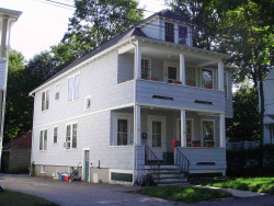
Property Use —
1 or 2 family dwelling
Bourne St Incidents registered in FEMA
(Federal Emergency Management Agency)
To date, we have no information about incidents registered in FEMA in 2025
06 Nov 2012
Gas leak (natural gas or LPG)
Property Use —
1 or 2 family dwelling
14 Feb 2003
Unintentional transmission of alarm, other
Property Use —
1 or 2 family dwelling
Properties Nearby
| Street Address | Residens/Landlords |
|---|