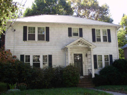
Information about property on 82 Athelstane Rd, Newton MA, 02459-2419. Find out owner contacts, building history, price, neighborhood at
Homemetry Address Directory.
Property Details
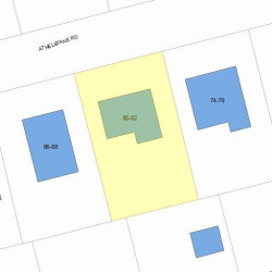
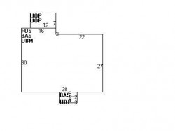
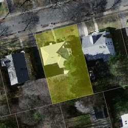
Constructed in 1930, this property has approximately thirty-four hundred square feet of effective area and sits on 0,19 acres.
Facts
Built in1930
Property useTwo Family
Lot size8,400 sqft
Effective area3,430 sqft
Building typeResidential
Rooms10
Bedrooms4
Stories2
Exterior conditionAverage
TrimNone
Foundation typeConcrete
Roof materialAsphalt Shingl
Fuel typeOil
Frontage75 feet
Basement area1,074 sqft
Porch area192 sqft
Heating & Cooling
Heat typeHot Wtr Radiat
Exterior Home Features
Exterior wallsWood Shingle
Roof typeHip
Features
Interior condition: Good
Householders and Tenants for 82 Athelstane Rd, Newton MA
FAQ about the house at 82 Athelstane Rd, Newton, MA
What year was the house at 82 Athelstane Rd, Newton, MA built?
The house at 82 Athelstane Rd, Newton, MA was built in 1930.
What type of house is at 82 Athelstane Rd, Newton, MA?
At the house at 82 Athelstane Rd, Newton, MA type Two Family.
Were there any reported FEMA incidents at 82 Athelstane Rd, Newton, MA?
The last FEMA incident recorded at 82 Athelstane Rd, Newton, MA was in 2004. Other FEMA incidents registered on Athelstane Rd are available at the link.
NOTICE: You may not use RadioAwards or the information it provides to make decisions about employment, credit, housing or any other purpose that would require Fair Credit Reporting Act (FCRA) compliance. RadioAwards is not a Consumer Reporting Agency (CRA) as defined by the FCRA and does not provide consumer reports.