Information about property on 79 Garland Rd, Newton MA, 02459-1741. Find out owner contacts, building history, price, neighborhood at
Homemetry Address Directory.
Property Details
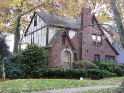
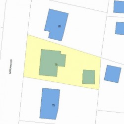
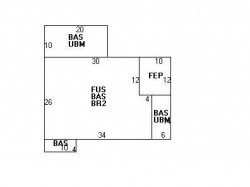
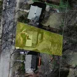
This property with near twenty-six hundred square feet of effective area on 0,16 acres was built in 1924.
Facts
Built in1924
Property useSingle Family
Lot size7,170 sqft
Effective area2,609 sqft
Gross building area3,236 sqft
Building typeResidential
Rooms7
Bedrooms3
Bathrooms1
Stories2
Exterior conditionAverage
TrimNone
Foundation typeBrick/Fldstone
Roof materialAsphalt Shingl
Fuel typeOil
Air conditioningCentral
Frontage70 feet
Basement area1,120 sqft
Finished basement area209 sqft
Enclosed porch area120 sqft
Detached garage area380 sqft
Heating & Cooling
Heat typeHot Wtr Radiat
Exterior Home Features
Exterior wallsBrick Veneer
Roof typeGable
Features
Kitchen quality: Above Average
Interior condition: Good
Householders and Tenants for 79 Garland Rd, Newton MA
What year was the house at 79 Garland Rd, Newton, MA built?
The house at 79 Garland Rd, Newton, MA was built in 1924.
What type of house is at 79 Garland Rd, Newton, MA?
At the house at 79 Garland Rd, Newton, MA type Residence for Single Family.
Were there any reported FEMA incidents at 79 Garland Rd, Newton, MA?
The last FEMA incident recorded at 79 Garland Rd, Newton, MA was in 2011. Other FEMA incidents registered on Garland Rd are available at the link.
NOTICE: You may not use RadioAwards or the information it provides to make decisions about employment, credit, housing or any other purpose that would require Fair Credit Reporting Act (FCRA) compliance. RadioAwards is not a Consumer Reporting Agency (CRA) as defined by the FCRA and does not provide consumer reports.