56 Sevland Rd, Newton MA  02459-2840 exterior

56 Sevland Rd Newton, MA 02459 / 2840

Residence for Single Family

(UPDATED: 08/11/2025)
  • 2 Beds
  • 3 Baths
  • 4.195 square feet
Property Report

Information about property on 56 Sevland Rd, Newton MA, 02459-2840. Find out owner contacts, building history, price, neighborhood at Homemetry Address Directory.

Property Details

Erected in the sixties, this property has near thirty-seven hundred square feet of effective area.

Facts

  • Built in 1962
  • Property use Single Family
  • Lot size 10,534 sqft
  • Effective area 3,738 sqft
  • Gross building area 4,195 sqft
  • Building type Residential
  • Rooms 7
  • Exterior condition Average
  • Trim Half Wall
  • Foundation type Concrete
  • Roof material Asphalt Shingl
  • Fuel type Oil
  • Air conditioning Central
  • Frontage 80 feet
  • Basement area 1,828 sqft
  • Finished basement area 1,371 sqft
  • Porch area 35 sqft
  • Deck area 176 sqft
  • Basement garages 2
  • Heating & Cooling
  • Heat type Hot Water
  • Exterior Home Features
  • Exterior walls Wood Shingle
  • Roof type Hip

Features

  • Kitchen quality: Good
  • Bath quality: Above Average

Householders and Tenants for 56 Sevland Rd, Newton MA

Possible residents contact details

Person Name Phone Number Additional Info
Alison H Wintman Age: 63
617-332-****
Residential status:
Homeowner
Audrey E Wintman Age: 96
617-332-****
Melvin R Wintman Age: 107
617-332-****
Rd T Sevland
Residential status:
Homeowner
SEVLAND ROAD NOMINEE TRUST
T T Sevland
Residential status:
Homeowner

Possible Businesses

Organization Phone Number Additional Info
Audrey Wintman
Industry:
Nonclassifiable Establishments
56 Sevland Rd, Newton MA  02459-2840 plot plan 56 Sevland Rd, Newton MA  02459-2840 floor plan 56 Sevland Rd, Newton MA  02459-2840 aerial view

Cost estimate history

YearAssessment
2016 $991,100
2015 $926,300
2014 $849,900
2013 $849,900
2012 $900,600
2011 $866,800
2010 $906,700
2009 $925,200
2008 $925,200
2007 $988,900
2006$960,100
2005$914,400
2004$861,300
2003$769,000
2002$769,000
2001$672,500
2000$614,200
1999$558,900
1998$454,900
1997$454,900
1996$433,200
1995$422,800
1994$412,500
1993$412,500
1992$370,700

Where is 56 Sevland Rd, Newton MA located on map?

Sevland Rd Incidents registered in FEMA
(Federal Emergency Management Agency)

To date, we have no information about incidents registered in FEMA in 2025
10 Apr 2003 Medical assist, assist EMS crew
Property Use —
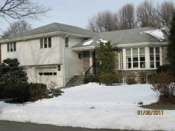
1 or 2 family dwelling

Properties Nearby

Street Address Residens/Landlords
4 Sevland Rd, Newton, MA 02459-2840
Single Family
  • 4 beds
  • 3.5 baths
  • 5,396 sqft
  • Built in 1957
SMOOKLER REALTY CORP, Andrew M Hyman
7 Sevland Rd, Newton, MA 02459-2841
Single Family
  • 3 beds
  • 2.5 baths
  • 3,383 sqft
  • Built in 1953
Henry K Paik, Rin K Paik
 

FAQ about the house at 56 Sevland Rd, Newton, MA


NOTICE: You may not use RadioAwards or the information it provides to make decisions about employment, credit, housing or any other purpose that would require Fair Credit Reporting Act (FCRA) compliance. RadioAwards is not a Consumer Reporting Agency (CRA) as defined by the FCRA and does not provide consumer reports.