Information about property on 7 Sevland Rd, Newton MA, 02459-2841. Find out owner contacts, building history, price, neighborhood at
Homemetry Address Directory.
Property Details
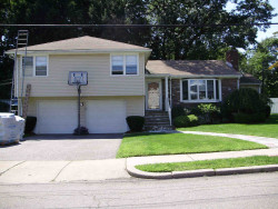
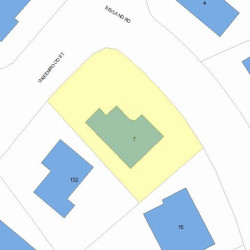
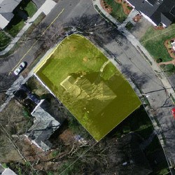
Originally built in the fifties, this property has more than twenty-three hundred square feet of effective area and sits on approximately one fourth of acre.
Facts
Built in1953
Property useSingle Family
Lot size10,802 sqft
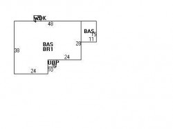
Effective area2,322 sqft
Gross building area3,383 sqft
Building typeResidential
Rooms7
Bedrooms3
Stories1
Exterior conditionAverage
TrimHalf Wall
Foundation typeConcrete
Roof materialAsphalt Shingl
Fuel typeOil
Air conditioningNone
Frontage120 feet
Basement area1,584 sqft
Finished basement area523 sqft
Porch area30 sqft
Deck area20 sqft
Basement garages2
Heating & Cooling
Heat typeHot Water
Exterior Home Features
Exterior wallsVinyl Siding
Roof typeHip
Householders and Tenants for 7 Sevland Rd, Newton MA
What year was the house at 7 Sevland Rd, Newton, MA built?
The house at 7 Sevland Rd, Newton, MA was built in 1953.
What type of house is at 7 Sevland Rd, Newton, MA?
At the house at 7 Sevland Rd, Newton, MA type Residence for Single Family.
Were there any reported FEMA incidents at 7 Sevland Rd, Newton, MA?
The last FEMA incident recorded at 7 Sevland Rd, Newton, MA was in 2003. Other FEMA incidents registered on Sevland Rd are available at the link.
NOTICE: You may not use RadioAwards or the information it provides to make decisions about employment, credit, housing or any other purpose that would require Fair Credit Reporting Act (FCRA) compliance. RadioAwards is not a Consumer Reporting Agency (CRA) as defined by the FCRA and does not provide consumer reports.