Information about property on 52 Bourne St, Newton MA, 02466-1722. Find out owner contacts, building history, price, neighborhood at
Homemetry Address Directory.
Property Details
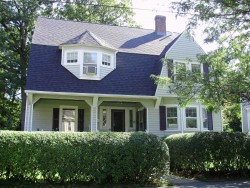
This property with approximately forty-two hundred square feet of effective area on 0,2 acres was originally built in 1892.
Facts
Built in1892
Property useSingle Family
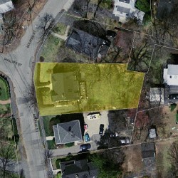
Lot size8,872 sqft
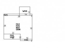
Effective area4,224 sqft
Gross building area4,832 sqft
Building typeResidential
Rooms8
Bedrooms4
Stories2
Exterior conditionAverage
TrimNone
Foundation typeBrick/Fldstone
Roof materialAsphalt Shingl
Fuel typeGas
Frontage68 feet
Finished attic area531 sqft
Basement area1,062 sqft
Porch area154 sqft
Deck area168 sqft
Heating & Cooling
Heat typeForced Air-Duc
Exterior Home Features
Exterior wallsVinyl Siding
Roof typeGambrel
Householders and Tenants for 52 Bourne St, Newton MA
What year was the house at 52 Bourne St, Newton, MA built?
The house at 52 Bourne St, Newton, MA was built in 1892.
What type of house is at 52 Bourne St, Newton, MA?
At the house at 52 Bourne St, Newton, MA type Residence for Single Family.
Were there any reported FEMA incidents at 52 Bourne St, Newton, MA?
The last FEMA incident recorded at 52 Bourne St, Newton, MA was in 2012. Other FEMA incidents registered on Bourne St are available at the link.
NOTICE: You may not use RadioAwards or the information it provides to make decisions about employment, credit, housing or any other purpose that would require Fair Credit Reporting Act (FCRA) compliance. RadioAwards is not a Consumer Reporting Agency (CRA) as defined by the FCRA and does not provide consumer reports.