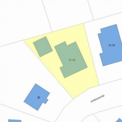
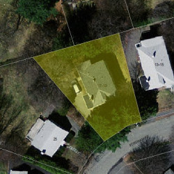
Information about property on 17 Fordham Rd, Newton MA, 02465-1206. Find out owner contacts, building history, price, neighborhood at
Homemetry Address Directory.
Units
Property details of units in this apartment building
#19
7,853 sqft
7 beds
3 baths
Multi-Family Home
Property Details
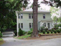
This property has approximately forty-eight hundred square feet of effective area and sits on 0,18 acres.
Facts
Built in1920
Property useTwo Family
Lot size7,853 sqft
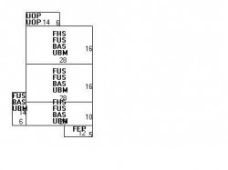
Effective area4,820 sqft
Gross building area5,184 sqft
Building typeResidential
Rooms13
Bedrooms7
Bathrooms3
Stories2
Exterior conditionAverage
TrimNone
Foundation typeConcrete
Roof materialAsphalt Shingl
Fuel typeGas
Frontage60 feet
Basement area1,260 sqft
Porch area168 sqft
Enclosed porch area60 sqft
Detached garage area324 sqft
Heating & Cooling
Heat typeForced Air-Duc
Exterior Home Features
Exterior wallsAluminum Sidng
Roof typeHip
Features
Kitchen quality: Above Average
Interior condition: Good
Householders and Tenants for 17 Fordham Rd, Newton MA
What year was the house at 17 Fordham Rd, Newton, MA built?
The house at 17 Fordham Rd, Newton, MA was built in 1920.
What type of house is at 17 Fordham Rd, Newton, MA?
At the house at 17 Fordham Rd, Newton, MA type Two Family.
Were there any reported FEMA incidents at 17 Fordham Rd, Newton, MA?
The last FEMA incident recorded at 17 Fordham Rd, Newton, MA was in 2003. Other FEMA incidents registered on Fordham Rd are available at the link.
NOTICE: You may not use RadioAwards or the information it provides to make decisions about employment, credit, housing or any other purpose that would require Fair Credit Reporting Act (FCRA) compliance. RadioAwards is not a Consumer Reporting Agency (CRA) as defined by the FCRA and does not provide consumer reports.