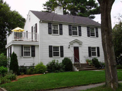
129 Upland Ave Newton, MA 02461 / 2112

Residence for Single Family

(UPDATED: 08/09/2025)
  • 3 Beds
  • 1 Baths
  • 2.670 square feet
Sold Feb 2022
$1,030,000
Property Report

Information about property on 129 Upland Ave, Newton MA, 02461-2112. Find out owner contacts, building history, price, neighborhood at Homemetry Address Directory.

Property Details

This is a single-family estate, which is situated at 129 Upland Avenue, Newton, MA.

Facts

  • Built in 1935
  • Property use Single Family
  • Lot size 6,551 sqft
  • Effective area 2,175 sqft
  • Gross building area 2,670 sqft
  • Building type Residential
  • Rooms 7
  • Bedrooms 3
  • Stories 2
  • Exterior condition Average
  • Trim None
  • Foundation type Concrete
  • Roof material Asphalt Shingl
  • Fuel type Gas
  • Frontage 72 feet
  • Basement area 660 sqft
  • Finished basement area 165 sqft
  • Deck area 474 sqft
  • Heating & Cooling
  • Heat type Steam
  • Exterior Home Features
  • Exterior walls Vinyl Siding
  • Roof type Gable

Features

  • Kitchen quality: Above Average

Householders and Tenants for 129 Upland Ave, Newton MA

Possible residents contact details

Person Name Phone Number Additional Info
David Pastor
Joseph H Freer Age: 61
617-778-****
Residential status:
Homeowner
Job:
Professional Specialty Occupations
Joyce Naggar Age: 54
617-244-****
Linda A Stoller
Lisa R Pastor
Lisa Rice Rice Age: 69
Marc D Greenbaum
Mark A Rosenstein Age: 62
617-497-****
Maureen E Finnerty
617-559-****
Residential status:
Homeowner
Maureen E Freer Age: 62
617-559-****
Residential status:
Homeowner
Job:
Professional Specialty Occupations
Michael Thornton Age: 67
617-559-****
Job:
Craftsman/Blue Collar
Morris M Naggar Age: 64
617-244-****
129 Upland Ave, Newton MA  02461-2112 plot plan 129 Upland Ave, Newton MA  02461-2112 floor plan 129 Upland Ave, Newton MA  02461-2112 aerial view

Purchase History

DateEventPriceSourceAgents
07/01/1999 Sold $435,000 Public records

Cost estimate history

YearAssessment
2016 $571,600
2015 $534,200
2014 $511,000
2013 $511,000
2012 $511,000
2011 $507,800
2010 $518,200
2009 $523,500
2008 $523,500
2007 $553,600
2006$537,500
2005$511,900
2004$469,200
2003$418,900
2002$418,900
2001$356,900
2000$325,900
1999$296,500
1998$278,700
1997$262,900
1996$237,300
1995$216,400
1994$214,300
1993$214,300
1992$214,600

Where is 129 Upland Ave, Newton MA located on map?

Market Activities

To date, we have no information about market activities in 2025
Feb 2022 Sold
129 Upland Ave
Price history :
  • Single Family
  • 1,536 sqft
  • 3 beds
  • 3 baths

View more

Building Permits

To date, we have no information about building permits in 2025
Jun 15, 2016
Description: Strip and reroof
  • Valuation: $500,000
  • Fee: $100.00 paid to City of Newton, Massachusetts
  • Parcel #: 83010 0026
  • Permit #: 16060537
Apr 30, 2008
Description: Remove exstg roof, install flat roof, deck & new door
  • Valuation: $1,200,000
  • Fee: $223.20 paid to City of Newton, Massachusetts
  • Parcel #: 83010 0026
  • Permit #: 08040695

Upland Ave Incidents registered in FEMA
(Federal Emergency Management Agency)

To date, we have no information about incidents registered in FEMA in 2025
24 Feb 2007 Gas leak (natural gas or LPG)
Property Use —
Residential street, road or residential driveway

Properties Nearby

Street AddressResidens/Landlords
 

FAQ about the house at 129 Upland Ave, Newton, MA


NOTICE: You may not use RadioAwards or the information it provides to make decisions about employment, credit, housing or any other purpose that would require Fair Credit Reporting Act (FCRA) compliance. RadioAwards is not a Consumer Reporting Agency (CRA) as defined by the FCRA and does not provide consumer reports.