12 Burnside Rd, Newton MA  02461-1401 exterior

12 Burnside Rd Newton, MA 02461 / 1401

Residence for Single Family

(UPDATED: 07/26/2025)
  • 3 Beds
  • 1 Baths
  • 4.582 square feet
Property Report

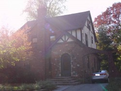
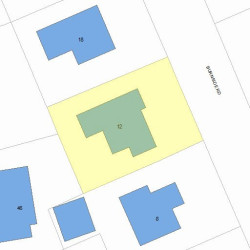
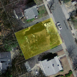
Information about property on 12 Burnside Rd, Newton MA, 02461-1401. Find out owner contacts, building history, price, neighborhood at Homemetry Address Directory.

Property Details

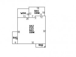
Put up in 1920, this property has more than forty hundred square feet of effective area and sits on 0,12 acres.

Facts

  • Built in 1920
  • Property use Single Family
  • Lot size 5,404 sqft
  • Effective area 4,090 sqft
  • Gross building area 4,582 sqft
  • Building type Residential
  • Rooms 8
  • Bedrooms 3
  • Bathrooms 1
  • Stories 2
  • Exterior condition Good
  • Trim None
  • Foundation type Concrete
  • Roof material Asphalt Shingl
  • Fuel type Gas
  • Frontage 61 feet
  • Unfinished attic area 492 sqft
  • Basement area 1,178 sqft
  • Deck area 130 sqft
  • Heating & Cooling
  • Heat type Hot Wtr Radiat
  • Exterior Home Features
  • Exterior walls Brick Veneer
  • Roof type Gable

Features

  • Bath quality: Above Average

Householders and Tenants for 12 Burnside Rd, Newton MA

Possible residents contact details

Person Name Phone Number Additional Info
Catherine W Hatch
Herman L Margolis
Jennifer R Feinstein Age: 57
617-332-****
Residential status:
Homeowner
Job:
Medical Professional
Jennifer R London Age: 57
617-332-****
Judy E Campbell
617-332-****
Julia T Mejia
617-332-****
Muriel C Margolis
Robert C Smith
Steve Feinstein
617-332-****
Steven R Feinstein Age: 66
617-332-****
Residential status:
Homeowner
12 Burnside Rd, Newton MA  02461-1401 plot plan 12 Burnside Rd, Newton MA  02461-1401 floor plan 12 Burnside Rd, Newton MA  02461-1401 aerial view

Purchase History

DateEventPriceSourceAgents
06/30/2009 Sold $810,000 Public records

Cost estimate history

YearAssessment
2016 $884,900
2015 $827,000
2014 $786,200
2013 $786,200
2012 $786,200
2011 $770,000
2010 $785,700
2009 $801,700
2008 $801,700
2007 $842,100
2006$817,600
2005$778,700
2004$719,200
2003$642,100
2002$642,100
2001$436,200
2000$398,400
1999$362,500
1998$335,100
1997$307,400
1996$292,800
1995$274,600
1994$259,100
1993$259,100
1992$267,000

Where is 12 Burnside Rd, Newton MA located on map?

Properties Nearby

Street AddressResidens/Landlords
5 Burnside Rd, Newton, MA 02461-1401
Single Family
  • 3 beds
  • 1.5 baths
  • 3,660 sqft
  • Built in 1926
Christopher J Roy, Laura E Bradbury
8 Burnside Rd, Newton, MA 02461-1401
Single Family
  • 3 beds
  • 1.5 baths
  • 3,996 sqft
  • Built in 1930
Miriam A Porter, Alyssa F Porter
11 Burnside Rd, Newton, MA 02461-1401
Single Family
  • 4 beds
  • 2.5 baths
  • 5,181 sqft
  • Built in 1925
MILTKE LISA VON, VONMILTKE LISA &AL
18 Burnside Rd, Newton, MA 02461-1401
Single Family
  • 3 beds
  • 2.5 baths
  • 4,010 sqft
  • Built in 1928
Jonathan I Clermont, M Clermont
19 Burnside Rd, Newton, MA 02461-1401
Single Family
  • 4 beds
  • 2.5 baths
  • 4,211 sqft
  • Built in 1927
Maureen K Oates, Brian G Oates
24 Burnside Rd, Newton, MA 02461-1401
Single Family
  • 5 beds
  • 3.5 baths
  • 4,502 sqft
  • Built in 1930
Katharine I Davidge, John R Dorfman
25 Burnside Rd, Newton, MA 02461-1401
Single Family
  • 3 beds
  • 2.5 baths
  • 3,134 sqft
  • Built in 1927
Elliott S Dobin, Debra A Wiener
Arnold Ariansen
Richard J Resnick
Charles A Grace
 

FAQ about the house at 12 Burnside Rd, Newton, MA


NOTICE: You may not use RadioAwards or the information it provides to make decisions about employment, credit, housing or any other purpose that would require Fair Credit Reporting Act (FCRA) compliance. RadioAwards is not a Consumer Reporting Agency (CRA) as defined by the FCRA and does not provide consumer reports.