102 Manchester Rd, Newton MA  02461-1123 exterior

102 Manchester Rd Newton, MA 02461 / 1123

Residence for Single Family

(UPDATED: 08/27/2025)
  • 2 Beds
  • 1 Baths
  • 2.488 square feet
Property Report

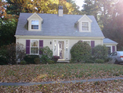
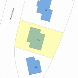
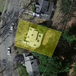
Information about property on 102 Manchester Rd, Newton MA, 02461-1123. Find out owner contacts, building history, price, neighborhood at Homemetry Address Directory.

Property Details

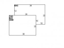
This property with 2,323 sqft of effective area on 0,13 acres was originally built in the thirties.

Facts

  • Built in 1930
  • Property use Single Family
  • Lot size 5,480 sqft
  • Effective area 2,323 sqft
  • Gross building area 2,488 sqft
  • Building type Residential
  • Rooms 7
  • Bedrooms 2
  • Bathrooms 1
  • Stories 1,75
  • Exterior condition Average
  • Trim None
  • Foundation type Concrete
  • Roof material Asphalt Shingl
  • Fuel type Gas
  • Frontage 60 feet
  • Basement area 660 sqft
  • Heating & Cooling
  • Heat type Steam
  • Exterior Home Features
  • Exterior walls Wood Shingle
  • Roof type Gable

Features

  • Bath quality: Below Average

Householders and Tenants for 102 Manchester Rd, Newton MA

Possible residents contact details

Person Name Phone Number Additional Info
BLUFERD REALTY TRUST
BLUFERD REALTY TRUST /S TR
Charles S Carrano Age: 57
617-332-****
Francine G Trester Age: 56
617-332-****
Holly M Dulac
James P Mcalpine Age: 94
617-780-****
Residential status:
Homeowner
Job:
Sales Occupations
Jas P Mcalpine Age: 94
617-527-****
John L Mcalpine Age: 66
617-527-****
Sally L Mcalpine Age: 94
617-527-****
Residential status:
Homeowner
Job:
Sales Occupations
102 Manchester Rd, Newton MA  02461-1123 plot plan 102 Manchester Rd, Newton MA  02461-1123 floor plan 102 Manchester Rd, Newton MA  02461-1123 aerial view

Purchase History

DateEventPriceSourceAgents
09/18/2003 Sold $455,000 Public records

Cost estimate history

YearAssessment
2016 $560,800
2015 $524,100
2014 $497,300
2013 $497,300
2012 $497,300
2011 $490,500
2010 $500,500
2009 $510,700
2008 $510,700
2007 $534,700
2006$519,100
2005$494,400
2004$456,000
2003$407,100
2002$407,100
2001$342,500
2000$312,800
1999$284,600
1998$259,500
1997$238,100
1996$226,800
1995$222,700
1994$216,200
1993$216,200
1992$208,700

Where is 102 Manchester Rd, Newton MA located on map?

Properties Nearby

Street AddressResidens/Landlords
10 Manchester Rd, Newton, MA 02461-1121
Single Family
  • 3 beds
  • 1 bath
  • 2,180 sqft
  • Built in 1939
WENNING JUNE D LIFE EST, Debra A Carroll
16 Manchester Rd, Newton, MA 02461-1121
Single Family
  • 3 beds
  • 2 baths
  • 3,926 sqft
  • Built in 1941
Lisa Spector, Kevin R Spector
20 Manchester Rd, Newton, MA 02461-1121
Single Family
  • 3 beds
  • 2 baths
  • 3,309 sqft
  • Built in 1931
Beth E Warach, Adam Lerner
24 Manchester Rd, Newton, MA 02461-1121
Single Family
  • 4 beds
  • 2.5 baths
  • 3,224 sqft
  • Built in 1935
PRATT SUZANNE ROBIN SULLIVAN, Robin S Pratt
29 Manchester Rd, Newton, MA 02461-1120
Single Family
  • 3 beds
  • 1.5 baths
  • 3,894 sqft
  • Built in 1930
Herbert M Brody, Garth W Brody
 

FAQ about the house at 102 Manchester Rd, Newton, MA


NOTICE: You may not use RadioAwards or the information it provides to make decisions about employment, credit, housing or any other purpose that would require Fair Credit Reporting Act (FCRA) compliance. RadioAwards is not a Consumer Reporting Agency (CRA) as defined by the FCRA and does not provide consumer reports.