93 Mccarthy Rd, Newton MA  02459-3645 exterior

93 Mccarthy Rd Newton, MA 02459 / 3645

Residence for Single Family

(UPDATED: 07/05/2025)
  • 4 Beds
  • 2 Baths
  • 1.660 square feet
Property Report

Information about property on 93 Mccarthy Rd, Newton MA, 02459-3645. Find out owner contacts, building history, price, neighborhood at Homemetry Address Directory.

Property Details

Built in the fifties, this property has near seventeen hundred square feet of effective area and sits on near a third of acre.

Facts

  • Built in 1950
  • Property use Single Family
  • Lot size 13,600 sqft
  • Effective area 1,660 sqft
  • Building type Residential
  • Rooms 7
  • Bedrooms 4
  • Bathrooms 2
  • Stories 1
  • Exterior condition Average
  • Trim None
  • Foundation type Slab
  • Roof material Asphalt Shingl
  • Fuel type Gas
  • Frontage 100 feet
  • Enclosed porch area 80 sqft
  • Detached garage area 220 sqft
  • Heating & Cooling
  • Heat type Hot Water
  • Exterior Home Features
  • Exterior walls Clapboard
  • Roof type Gable

Householders and Tenants for 93 Mccarthy Rd, Newton MA

Possible residents contact details

Person Name Phone Number Additional Info
C Moloney
617-332-****
Carole H Moloney Age: 63
617-332-****
Residential status:
Homeowner
Christopher K Moloney Age: 34
617-332-****
Residential status:
Homeowner
Deborah Erba
Deborah Ward
Irit Gazit Age: 74
K Moloney
617-332-****
Kaitlyn E Moloney Age: 28
617-332-****
Residential status:
Homeowner
Kevin C Moloney Age: 65
617-332-****
Residential status:
Homeowner
Job:
Production Occupations
Marie T Hauer
93 Mccarthy Rd, Newton MA  02459-3645 plot plan 93 Mccarthy Rd, Newton MA  02459-3645 floor plan 93 Mccarthy Rd, Newton MA  02459-3645 aerial view

Purchase History

DateEventPriceSourceAgents
01/06/1997 Sold $203,530 Public records

Cost estimate history

YearAssessment
2016 $431,900
2015 $403,600
2014 $382,900
2013 $382,900
2012 $382,900
2011 $382,200
2010 $390,000
2009 $398,000
2008 $398,000
2007 $457,800
2006$444,500
2005$423,300
2004$349,600
2003$312,100
2002$312,100
2001$274,800
2000$251,000
1999$228,400
1998$207,100
1997$190,000
1996$190,000
1995$197,400
1994$171,200
1993$171,200
1992$190,200

Where is 93 Mccarthy Rd, Newton MA located on map?

Mccarthy Rd Incidents registered in FEMA
(Federal Emergency Management Agency)

To date, we have no information about incidents registered in FEMA in 2025
16 Jul 2003 Unintentional transmission of alarm, other
Property Use —
1 or 2 family dwelling
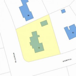
Properties Nearby

Street AddressResidens/Landlords
BOSCO HO WING-FEI, Wing Ho
69 Mccarthy Rd, Newton, MA 02459-3644
Single Family
  • 3 beds
  • 2.5 baths
  • 1,646 sqft
  • Built in 1949
JAMIE W KLEIN REVOCABLE TRUST, Jamie W Klein
75 Mccarthy Rd, Newton, MA 02459-3644
Single Family
  • 5 beds
  • 3.5 baths
  • 3,240 sqft
  • Built in 1949
MORALES REALTY TRUST /S TRS, Mariflor Salas
76 Mccarthy Rd, Newton, MA 02459-3613
Single Family
  • 5 beds
  • 4.5 baths
  • 5,058 sqft
  • Built in 1948
Leonid Gamburg, Irene M Gamburg
Robyn L Doane, Lisa Zuckerman
86 Mccarthy Rd, Newton, MA 02459-3613
Single Family
  • 4 beds
  • 2.5 baths
  • 5,354 sqft
  • Built in 2005
Robyn L Doane, Lisa Zuckerman
Yen Chen
 

FAQ about the house at 93 Mccarthy Rd, Newton, MA


NOTICE: You may not use RadioAwards or the information it provides to make decisions about employment, credit, housing or any other purpose that would require Fair Credit Reporting Act (FCRA) compliance. RadioAwards is not a Consumer Reporting Agency (CRA) as defined by the FCRA and does not provide consumer reports.