Information about property on 87 Winslow Rd, Newton MA, 02468-1711. Find out owner contacts, building history, price, neighborhood at
Homemetry Address Directory.
Property Details
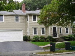
Developed in the thirties, this property has more than fifty hundred square feet of effective area and sits on 0,28 acres.
Facts
Built in1939
Property useSingle Family
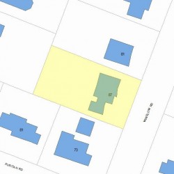
Lot size12,000 sqft
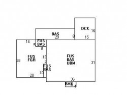
Effective area5,084 sqft
Building typeResidential
Rooms9
Bedrooms5
Stories2
Exterior conditionAverage
TrimNone
Foundation typeConc Block
Roof materialAsphalt Shingl
Fuel typeGas
Air conditioningCentral
Frontage80 feet
Basement area1,116 sqft
Deck area240 sqft
Attached garage area556 sqft
Heating & Cooling
Heat typeForced Air-Duc
Exterior Home Features
Exterior wallsClapboard
Roof typeHip
Features
Kitchen quality: Good
Householders and Tenants for 87 Winslow Rd, Newton MA
What year was the house at 87 Winslow Rd, Newton, MA built?
The house at 87 Winslow Rd, Newton, MA was built in 1939.
What type of house is at 87 Winslow Rd, Newton, MA?
At the house at 87 Winslow Rd, Newton, MA type Residence for Single Family.
Were there any reported FEMA incidents at 87 Winslow Rd, Newton, MA?
The last FEMA incident recorded at 87 Winslow Rd, Newton, MA was in 2004. Other FEMA incidents registered on Winslow Rd are available at the link.
NOTICE: You may not use RadioAwards or the information it provides to make decisions about employment, credit, housing or any other purpose that would require Fair Credit Reporting Act (FCRA) compliance. RadioAwards is not a Consumer Reporting Agency (CRA) as defined by the FCRA and does not provide consumer reports.