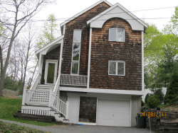
79 Cummings Rd, Newton MA  02459-1754 exterior

79 Cummings Rd Newton, MA 02459 / 1754

Residence for Single Family

(UPDATED: 07/20/2025)
  • 3 Beds
  • 2 Baths
  • 2.908 square feet
Property Report

Information about property on 79 Cummings Rd, Newton MA, 02459-1754. Find out owner contacts, building history, price, neighborhood at Homemetry Address Directory.

Property Details

This property with near twenty-nine hundred square feet of effective area on 0,25 acres was erected in the eighties.

Facts

  • Built in 1986
  • Property use Single Family
  • Lot size 11,000 sqft
  • Effective area 2,908 sqft
  • Building type Residential
  • Rooms 5
  • Bedrooms 3
  • Stories 2
  • Exterior condition Average
  • Trim None
  • Foundation type Concrete
  • Roof material Asphalt Shingl
  • Fuel type Gas
  • Air conditioning Central
  • Frontage 82 feet
  • Basement area 900 sqft
  • Shed area 120 sqft
  • Porch area 20 sqft
  • Deck area 312 sqft
  • Basement garages 1
  • Heating & Cooling
  • Heat type Forced Air-Duc
  • Exterior Home Features
  • Exterior walls Wood Shingle
  • Roof type Gable

Features

  • Interior condition: Good

Householders and Tenants for 79 Cummings Rd, Newton MA

Possible residents contact details

Person Name Phone Number Additional Info
A H Fossel
617-527-****
Anne H Fosel Age: 81
617-527-****
Anne H Fossel Age: 81
617-527-****
CARDING ANNIE M EST
Christopher R Felax
617-916-****
Eric T Fossel Age: 83
GAUTHIER KASHA L MARTIN
H Fossel
617-527-****
J F M REALTY TRUST
JFM REALTY TRUST
John E Carding
John F Tr Medaglia
Kasha M Gauthier Age: 49
617-965-****
Residential status:
Homeowner
Kevin M Gauthier Age: 59
617-965-****
Residential status:
Homeowner
Mossa Sabetfard
79 Cummings Rd, Newton MA  02459-1754 plot plan 79 Cummings Rd, Newton MA  02459-1754 floor plan 79 Cummings Rd, Newton MA  02459-1754 aerial view

Purchase History

DateEventPriceSourceAgents
05/15/2009 Sold $690,000 Public records

Cost estimate history

YearAssessment
2016 $735,500
2015 $687,400
2014 $652,400
2013 $652,400
2012 $650,500
2011 $647,600
2010 $652,200
2009 $665,500
2008 $665,500
2007 $695,600
2006$675,300
2005$643,100
2004$584,200
2003$521,600
2002$521,600
2001$455,400
2000$415,900
1999$378,400
1998$303,300
1997$278,300
1996$265,000
1995$264,100
1994$264,100
1993$264,100
1992$301,300

Where is 79 Cummings Rd, Newton MA located on map?

Building Permits

To date, we have no information about building permits in 2025
Sep 9, 2015
Description: Strip and reroof
  • Valuation: $2,000,000
  • Fee: $400.00 paid to City of Newton, Massachusetts
  • Parcel #: 64003 0038
  • Permit #: 15090283
Sep 28, 2011
Description: Install 10x12 shed 5 feet off rear property lines
  • Valuation: $344,400
  • Fee: $64.06 paid to City of Newton, Massachusetts
  • Parcel #: 64003 0038
  • Permit #: 11090728

Cummings Rd Incidents registered in FEMA
(Federal Emergency Management Agency)

To date, we have no information about incidents registered in FEMA in 2025
31 Dec 2003 Medical assist, assist EMS crew
Property Use —
1 or 2 family dwelling
16 Nov 2003 Good intent call, other
Property Use —
1 or 2 family dwelling

Properties Nearby

Street AddressResidens/Landlords
9 Cummings Rd, Newton, MA 02459-1734
Single Family
  • 3 beds
  • 2.5 baths
  • 3,530 sqft
  • Built in 1940
Patricia H Rex, Michael Tr Gnecco
 

FAQ about the house at 79 Cummings Rd, Newton, MA


NOTICE: You may not use RadioAwards or the information it provides to make decisions about employment, credit, housing or any other purpose that would require Fair Credit Reporting Act (FCRA) compliance. RadioAwards is not a Consumer Reporting Agency (CRA) as defined by the FCRA and does not provide consumer reports.