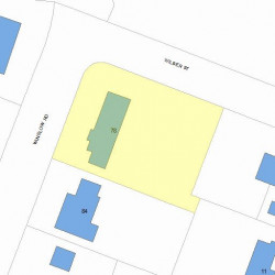
Information about property on 78 Winslow Rd, Newton MA, 02468-1712. Find out owner contacts, building history, price, neighborhood at
Homemetry Address Directory.
Property Details
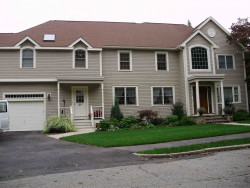
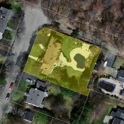
A single-family residence at 78 Winslow Road, Newton, MA.
Facts
Built in1943
Property useSingle Family
Lot size17,314 sqft
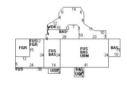
Effective area5,752 sqft
Building typeResidential
Rooms11
Bedrooms4
Stories2
Exterior conditionAverage
TrimNone
Foundation typeConcrete
Roof materialAsphalt Shingl
Fuel typeOil
Air conditioningCentral
Frontage110 feet
Basement area984 sqft
Porch area72 sqft
Swimming poolAVG ABV GRND
Cabana area176 sqft
Deck area604 sqft
Attached garage area576 sqft
Heating & Cooling
Heat typeHot Wtr Radiat
Exterior Home Features
Exterior wallsClapboard
Roof typeHip
Features
Interior condition: Good
Householders and Tenants for 78 Winslow Rd, Newton MA
What year was the house at 78 Winslow Rd, Newton, MA built?
The house at 78 Winslow Rd, Newton, MA was built in 1943.
What type of house is at 78 Winslow Rd, Newton, MA?
At the house at 78 Winslow Rd, Newton, MA type Residence for Single Family.
Were there any reported FEMA incidents at 78 Winslow Rd, Newton, MA?
The last FEMA incident recorded at 78 Winslow Rd, Newton, MA was in 2004. Other FEMA incidents registered on Winslow Rd are available at the link.
NOTICE: You may not use RadioAwards or the information it provides to make decisions about employment, credit, housing or any other purpose that would require Fair Credit Reporting Act (FCRA) compliance. RadioAwards is not a Consumer Reporting Agency (CRA) as defined by the FCRA and does not provide consumer reports.