73 Perkins St, Newton MA  02465-2302 exterior

73 Perkins St Newton, MA 02465 / 2302

Residence for Single Family

(UPDATED: 08/14/2025)
  • 7 Beds
  • 4 Baths
  • 6.991 square feet
Property Report

Information about property on 73 Perkins St, Newton MA, 02465-2302. Find out owner contacts, building history, price, neighborhood at Homemetry Address Directory.

Property Details

At 73 Perkins St, Newton, MA stands a property, which was built in 1875.

Facts

  • Built in 1875
  • Property use Single Family
  • Lot size 18,477 sqft
  • Effective area 6,776 sqft
  • Gross building area 6,991 sqft
  • Building type Residential
  • Rooms 13
  • Bedrooms 7
  • Bathrooms 4
  • Stories 2,75
  • Exterior condition Good
  • Trim None
  • Foundation type Brick/Fldstone
  • Roof material Asphalt Shingl
  • Fuel type Gas
  • Air conditioning Central
  • Frontage 28 feet
  • Basement area 1,543 sqft
  • Porch area 622 sqft
  • Deck area 517 sqft
  • Heating & Cooling
  • Heat type Forced Air-Duc
  • Exterior Home Features
  • Exterior walls Clapboard
  • Roof type Gable

Features

  • Bath quality: Above Average

Householders and Tenants for 73 Perkins St, Newton MA

Possible residents contact details

Person Name Phone Number Additional Info
Andrew R Martin
KEPESAKE REALTY TRUST /S TRS
Laurel H Farnsworth Age: 71
617-244-****
Residential status:
Homeowner
Sarah Farnsworth Age: 39
617-244-****
Stephen Downey Age: 41
617-244-****
Thomas S Downey
Vincent L A Wares
Wendy H Farnsworth Age: 68
617-244-****

Businesses

Organization Phone Number Additional Info
Downey-Farnsworth Fam Charitable Foundation
Industry:
Membership Organization
73 Perkins St, Newton MA  02465-2302 plot plan 73 Perkins St, Newton MA  02465-2302 floor plan 73 Perkins St, Newton MA  02465-2302 aerial view

Cost estimate history

YearAssessment
2016 $1,676,200
2015 $1,566,500
2014 $1,480,500
2013 $1,493,100
2012 $1,493,100
2011 $1,461,900
2010 $1,491,700
2009 $1,522,100
2008 $1,522,100
2007 $1,601,400
2006$1,554,800
2005$1,480,800
2004$1,359,500
2003$1,213,800
2002$1,055,400
2001$722,000
2000$659,400
1999$511,300
1998$384,800
1997$366,500
1996$299,600
1995$318,700
1994$318,700
1993$267,000
1992$350,100

Where is 73 Perkins St, Newton MA located on map?

Perkins St Incidents registered in FEMA
(Federal Emergency Management Agency)

To date, we have no information about incidents registered in FEMA in 2025
14 Apr 2004 Fuel burner/boiler malfunction, fire confined
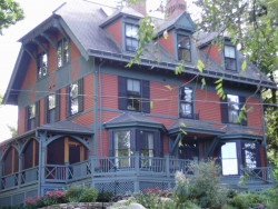
Property Use —
1 or 2 family dwelling
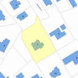
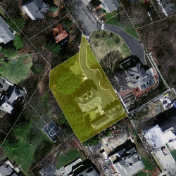
Properties Nearby

Street Address Residens/Landlords
7 Perkins St, Newton, MA 02465-2302
Condominium (Residential)
  • 3 beds
  • 2 baths
  • Lot: 0.26 acres
  • Built in 1999
Alesia H Napier, Philip J Goddard
Joseph W Furey, Julia R Furey
F F Gorman Brigham Jr, Chester H Hall
Donald J Larson, Laura K Larson
 

FAQ about the house at 73 Perkins St, Newton, MA


NOTICE: You may not use RadioAwards or the information it provides to make decisions about employment, credit, housing or any other purpose that would require Fair Credit Reporting Act (FCRA) compliance. RadioAwards is not a Consumer Reporting Agency (CRA) as defined by the FCRA and does not provide consumer reports.