Information about property on 67 Brackett Rd, Newton MA, 02458-2613. Find out owner contacts, building history, price, neighborhood at
Homemetry Address Directory.
Property Details
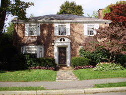
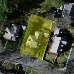
At 67 Brackett Road, Newton, MA placed a property, which was built in 1939 and is positioned at the end of the street.
Facts
Built in1939
Property useSingle Family
Lot size9,385 sqft
Effective area3,813 sqft
Gross building area4,725 sqft
Building typeResidential
Rooms10
Bedrooms4
Stories2
Exterior conditionAverage
TrimNone
Foundation typeConcrete
Roof materialSlate
Fuel typeGas
Air conditioningCentral
Frontage75 feet
Basement area1,251 sqft
Finished basement area304 sqft
Porch area25 sqft
Attached garage area400 sqft
Heating & Cooling
Heat typeForced Air-Duc
Exterior Home Features
Exterior wallsBrick Veneer
Roof typeHip
Features
Kitchen quality: Above Average
Householders and Tenants for 67 Brackett Rd, Newton MA
What year was the house at 67 Brackett Rd, Newton, MA built?
The house at 67 Brackett Rd, Newton, MA was built in 1939.
What type of house is at 67 Brackett Rd, Newton, MA?
At the house at 67 Brackett Rd, Newton, MA type Residence for Single Family.
Were there any reported FEMA incidents at 67 Brackett Rd, Newton, MA?
The last FEMA incident recorded at 67 Brackett Rd, Newton, MA was in 2008. Other FEMA incidents registered on Brackett Rd are available at the link.
NOTICE: You may not use RadioAwards or the information it provides to make decisions about employment, credit, housing or any other purpose that would require Fair Credit Reporting Act (FCRA) compliance. RadioAwards is not a Consumer Reporting Agency (CRA) as defined by the FCRA and does not provide consumer reports.