
Cost estimate history
| Year | Assessment | ||
|---|---|---|---|
| 2016 | $447,300 | ||
| 2015 | $418,000 | ||
| 2014 | $398,600 | ||
| 2013 | $398,600 | ||
| 2012 | $398,600 | ||
| 2011 | $398,100 | ||
| 2010 | $384,500 | ||
| 2009 | $392,300 | ||
| 2008 | $392,300 | ||
| 2007 | $402,100 | ||
| 2006 | $390,400 | ||
| 2005 | $371,800 | ||
| 2004 | $338,900 | ||
| 2003 | $302,600 | ||
| 2002 | $302,600 | ||
| 2001 | $244,800 | ||
| 2000 | $223,600 | ||
| 1999 | $203,500 | ||
| 1998 | $184,900 | ||
| 1997 | $169,600 | ||
| 1996 | $161,500 | ||
| 1995 | $148,400 | ||
| 1994 | $148,400 | ||
| 1993 | $158,000 | ||
| 1992 | $170,400 |
Market Activities
To date, we have no information about market activities in 2025
Jun 2022
Sold
Feb 2022
Sold
Jan 2018
Sold
Cummings Rd Incidents registered in FEMA
(Federal Emergency Management Agency)
To date, we have no information about incidents registered in FEMA in 2025
31 Dec 2003
Medical assist, assist EMS crew
Property Use —
1 or 2 family dwelling
16 Nov 2003
Good intent call, other
Property Use —
1 or 2 family dwelling
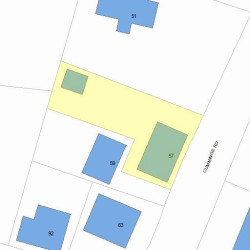
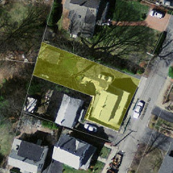
Properties Nearby
| Street Address | Residens/Landlords |
|---|