52 Harding St Newton, MA 02465 / 1320

Residence for Single Family

(UPDATED: 08/02/2025)
  • 4 Beds
  • 1 Baths
  • 2.884 square feet
Sold Oct 2024
$920,000
Property Report

Information about property on 52 Harding St, Newton MA, 02465-1320. Find out owner contacts, building history, price, neighborhood at Homemetry Address Directory.

Property Details

This property with approximately two thousand square feet of effective area on 0,17 acres was originally built in the twenties.

Facts

  • Built in 1925
  • Property use Single Family
  • Lot size 7,289 sqft
  • Effective area 1,984 sqft
  • Gross building area 2,884 sqft
  • Building type Residential
  • Rooms 7
  • Bedrooms 4
  • Bathrooms 1
  • Stories 1,75
  • Exterior condition Average
  • Trim None
  • Foundation type Concrete
  • Roof material Asphalt Shingl
  • Fuel type Gas
  • Frontage 60 feet
  • Basement area 900 sqft
  • Finished basement area 225 sqft
  • Porch area 120 sqft
  • Deck area 64 sqft
  • Detached garage area 400 sqft
  • Heating & Cooling
  • Heat type Steam
  • Exterior Home Features
  • Exterior walls Wood Shingle
  • Roof type Gable

Features

  • Bath quality: Below Average
  • Interior condition: Good

Householders and Tenants for 52 Harding St, Newton MA

Possible residents contact details

Person Name Phone Number Additional Info
Christa A Lyons Age: 53
617-558-****
David J Lyons Age: 54
617-558-****
Gloria J Coakley
Harold W Coakley
J Lyons
617-558-****
James R Lyons Age: 84
617-504-****
Residential status:
Homeowner
Job:
Machine Operators, Assemblers, and Inspectors Occupations
PLUHKSNE MICHAEL EST
PLUHKSNE OLGA
Paul M Lyons Age: 54
703-209-****
Residential status:
Homeowner
Job:
Machine Operators, Assemblers, and Inspectors Occupations
Rosalie E Lyons
52 Harding St, Newton MA  02465-1320 plot plan 52 Harding St, Newton MA  02465-1320 floor plan 52 Harding St, Newton MA  02465-1320 aerial view

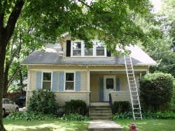
Cost estimate history

YearAssessment
2016 $575,200
2015 $537,600
2014 $510,800
2013 $510,800
2012 $510,800
2011 $505,700
2010 $516,000
2009 $526,500
2008 $526,500
2007 $525,800
2006$510,500
2005$486,200
2004$454,000
2003$405,400
2002$405,400
2001$314,200
2000$286,900
1999$261,100
1998$233,100
1997$219,900
1996$209,400
1995$170,600
1994$170,600
1993$170,600
1992$188,800

Where is 52 Harding St, Newton MA located on map?

Market Activities

To date, we have no information about market activities in 2025
Oct 2024 Sold
52 Harding St
Price history :
  • Single Family
  • 1,575 sqft
  • 4 beds
  • 2 baths
Sep 2024 Sold
52 Harding St
Price history :
  • Single Family
  • 1,575 sqft
  • 4 beds
  • 2 baths

View more

Harding St Fire Incident History

To date, we have no information about fire incidents in 2025
30 Mar 2002 Building fires
Property Use —
Mental retardation/development disability facility
Area of Origin —
Exterior balcony, unenclosed porch
First Ignition —
Multiple items first ignited

Harding St Incidents registered in FEMA
(Federal Emergency Management Agency)

To date, we have no information about incidents registered in FEMA in 2025
07 Dec 2013 Carbon monoxide incident
Property Use —
1 or 2 family dwelling
15 Dec 2007 Arcing, shorted electrical equipment
Property Use —
Residential street, road or residential driveway

Properties Nearby

Street Address Residens/Landlords
 

FAQ about the house at 52 Harding St, Newton, MA


NOTICE: You may not use RadioAwards or the information it provides to make decisions about employment, credit, housing or any other purpose that would require Fair Credit Reporting Act (FCRA) compliance. RadioAwards is not a Consumer Reporting Agency (CRA) as defined by the FCRA and does not provide consumer reports.