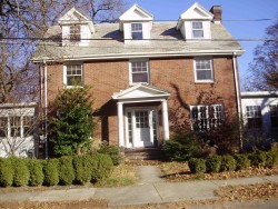
Purchase History
| Date | Event | Price | Source | Agents |
|---|---|---|---|---|
| 07/29/1997 | Sold | $459,000 | Public records |
Cost estimate history
| Year | Assessment | ||
|---|---|---|---|
| 2016 | $992,400 | ||
| 2015 | $927,500 | ||
| 2014 | $891,400 | ||
| 2013 | $891,400 | ||
| 2012 | $891,400 | ||
| 2011 | $898,000 | ||
| 2010 | $916,300 | ||
| 2009 | $935,000 | ||
| 2008 | $894,000 | ||
| 2007 | $865,500 | ||
| 2006 | $840,300 | ||
| 2005 | $800,300 | ||
| 2004 | $753,600 | ||
| 2003 | $672,900 | ||
| 2002 | $672,900 | ||
| 2001 | $551,100 | ||
| 2000 | $503,300 | ||
| 1999 | $458,000 | ||
| 1998 | $376,200 | ||
| 1997 | $368,800 | ||
| 1996 | $351,200 | ||
| 1995 | $321,900 | ||
| 1994 | $300,800 | ||
| 1993 | $300,800 | ||
| 1992 | $314,400 |
Stuart Rd Fire Incident History
To date, we have no information about fire incidents in 2025
05 Sep 2008
Natural vegetation fire, other
Property Use —
1 or 2 family dwelling
Area of Origin —
Outside area, other
First Ignition —
Chips, including wood chips
Heat Source —
Cigarette
Stuart Rd Incidents registered in FEMA
(Federal Emergency Management Agency)
To date, we have no information about incidents registered in FEMA in 2025
09 Jun 2010
Arcing, shorted electrical equipment
Property Use —
1 or 2 family dwelling
11 May 2010
Chemical spill or leak
Property Use —
1 or 2 family dwelling
15 Nov 2003
Smoke scare, odor of smoke
Property Use —
Residential, other
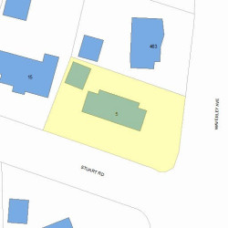
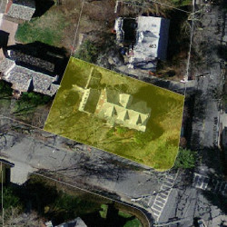
Properties Nearby
| Street Address | Residens/Landlords |
|---|