Cost estimate history
| Year | Assessment | ||
|---|---|---|---|
| 2016 | $512,500 | ||
| 2015 | $479,000 | ||
| 2014 | $458,300 | ||
| 2013 | $458,300 | ||
| 2012 | $458,300 | ||
| 2011 | $448,300 | ||
| 2010 | $457,400 | ||
| 2009 | $466,700 | ||
| 2008 | $466,700 | ||
| 2007 | $475,800 | ||
| 2006 | $461,900 | ||
| 2005 | $439,900 | ||
| 2004 | $401,200 | ||
| 2003 | $358,200 | ||
| 2002 | $358,200 | ||
| 2001 | $296,100 | ||
| 2000 | $270,400 | ||
| 1999 | $246,000 | ||
| 1998 | $221,800 | ||
| 1997 | $206,300 | ||
| 1996 | $196,500 | ||
| 1995 | $190,000 | ||
| 1994 | $190,000 | ||
| 1993 | $196,200 | ||
| 1992 | $208,000 |
Building Permits
To date, we have no information about building permits in 2025
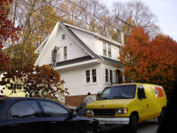
May 24, 2010
Description: New foundation and proposed 14'x20' garage (tree fell on existing garage) 3ft off property line
- Valuation: $2,000,000
- Fee: $744.00 paid to City of Newton, Massachusetts
- Parcel #: 71037 0009
- Permit #: 10050433
Playstead Rd Crime Incidents History
To date, we have no information about crime incidents in 2025
27 Sep 2012
Proactive Policing
1 Block Playstead Rd, Newton MA
Case Number —
2012-0005057
Description —
STRAIGHT WARRANT
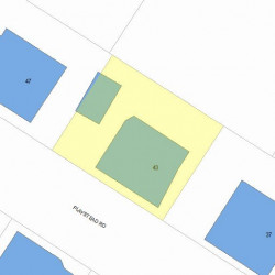
Properties Nearby
| Street Address | Residens/Landlords |
|---|