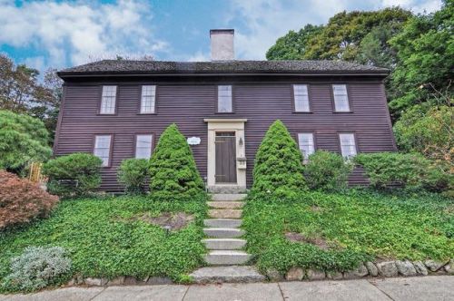
33 High St Ipswich, MA 01938 / 1905

Residence for Single Family

(UPDATED: 08/03/2025)
  • 4 Beds
  • 2 Baths
  • 3.482 square feet
Sold Jan 2018
$725,000
Property Report

Information about property on 33 High St, Ipswich MA, 01938-1905. Find out owner contacts, building history, price, neighborhood at Homemetry Address Directory.

Property Details

A large single-family two-story residence at 33 High St, Ipswich, Massachusetts.

Facts

  • Built in 1652
  • Lot size 1 acres
  • Floor size 3,482 sqft
  • Rooms 9
  • Bedrooms 4
  • Bathrooms 2,5
  • Stories 2
  • Heating & Cooling
  • Heat type Other
  • Exterior Home Features
  • Exterior material Wood
  • Roof type Shake Shingle

Misc

  • Units 1

Listing info

  • Last sold May 1997 for $254,900

Features

  • Fireplace

Householders and Tenants for 33 High St, Ipswich MA

Possible residents contact details

Person Name Phone Number Additional Info
Deborah L Trevarrow Age: 62
978-356-****
Residential status:
Homeowner
Job:
Service Occupations
Jean B Goodrich
978-356-****
Residential status:
Homeowner
Robert J Trevarrow Age: 63
Ronald J Trevarrow Age: 63
978-356-****
Residential status:
Homeowner
Job:
Service Occupations

Where is 33 High St, Ipswich MA located on map?

Market Activities

To date, we have no information about market activities in 2025
Jan 2018 Sold
33 High St
Price history :
  • 3,392
  • 4 beds
  • 3 baths
Oct 2017 Sold
33 High St
Price history :
  • 3,392
  • 4 beds
  • 3 baths

View more

High St Fire Incident History

To date, we have no information about fire incidents in 2025
03 Oct 2019 Cooking fire, confined to container
Property Use —
Restaurant or cafeteria
Area of Origin —
Cooking area, kitchen
First Ignition —
Item First Ignited, Other
Heat Source —
Heat source: other
10 Jun 2019 Cooking fire, confined to container
Property Use —
1 or 2 family dwelling
Area of Origin —
Cooking area, kitchen
First Ignition —
Item First Ignited, Other
Heat Source —
Heat source: other
24 Apr 2019 Brush, or brush and grass mixture fire
Property Use —
Graded and cared-for plots of land
Area of Origin —
Open area - outside; included are farmland, field
First Ignition —
Light vegetation - not crop, including grass
Heat Source —
Hot ember or ash
21 Apr 2019 Cooking fire, confined to container
Property Use —
1 or 2 family dwelling
Area of Origin —
Cooking area, kitchen
First Ignition —
Item First Ignited, Other
Heat Source —
Heat source: other

View more

High St Incidents registered in FEMA
(Federal Emergency Management Agency)

To date, we have no information about incidents registered in FEMA in 2025
07 Nov 2015 Arcing, shorted electrical equipment
Property Use —
Eating, drinking places
07 Nov 2015 Vehicle accident, general cleanup
Property Use —
Residential street, road or residential driveway
03 Oct 2015 Arcing, shorted electrical equipment
Property Use —
Street, other
12 Sep 2015 Vehicle accident, general cleanup
Property Use —
Highway or divided highway

View more

Properties Nearby

Street AddressResidens/Landlords
34 High St, Ipswich, MA 01938-1946
Single Family
  • 5 beds
  • 3.5 baths
  • 2,656 sqft
  • Built in 1659
YANKEE ENGINEERING, INC, Blanche Patch
36 High St, Ipswich, MA 01938-1946
Townhouse
  • 2 beds
  • 2.5 baths
  • 2,266 sqft
  • Built in 1900
P Belperron, Pierre A Belperron
37 High St, Ipswich, MA 01938-1905
Multiple Occupancy
  • 4 beds
  • 3 baths
  • 2,724 sqft
  • Built in 1725
Ellen J Gawlocki, Gan Heisermann
38 High St, Ipswich, MA 01938-1946
Single Family
  • 3 beds
  • 1.5 baths
  • 1,688 sqft
  • Built in 1900
Grant W Edmonds, Reginald W Edmonds
 

FAQ about the house at 33 High St, Ipswich, MA


NOTICE: You may not use RadioAwards or the information it provides to make decisions about employment, credit, housing or any other purpose that would require Fair Credit Reporting Act (FCRA) compliance. RadioAwards is not a Consumer Reporting Agency (CRA) as defined by the FCRA and does not provide consumer reports.