33 Avondale Rd, Newton MA  02459-1618 exterior

33 Avondale Rd Newton, MA 02459 / 1618

Residence for Single Family

(UPDATED: 09/09/2025)
  • 3 Beds
  • 3 Baths
  • 3.554 square feet
Property Report

Information about property on 33 Avondale Rd, Newton MA, 02459-1618. Find out owner contacts, building history, price, neighborhood at Homemetry Address Directory.

Property Details

A single-family property at 33 Avondale Rd, Newton, MA.

Facts

  • Built in 1941
  • Property use Single Family
  • Lot size 9,211 sqft
  • Effective area 3,554 sqft
  • Building type Residential
  • Rooms 9
  • Bedrooms 3
  • Stories 2
  • Exterior condition Average
  • Trim None
  • Foundation type Concrete
  • Roof material Asphalt Shingl
  • Fuel type Oil
  • Air conditioning Central
  • Frontage 160 feet
  • Basement area 976 sqft
  • Finished basement area 192 sqft
  • Enclosed porch area 98 sqft
  • Deck area 140 sqft
  • Basement garages 1
  • Heating & Cooling
  • Heat type Steam
  • Exterior Home Features
  • Exterior walls Brick/Masonry
  • Roof type Gable

Features

  • Kitchen quality: Good

Householders and Tenants for 33 Avondale Rd, Newton MA

Possible residents contact details

Person Name Phone Number Additional Info
Dwight E Sargent
Elaine M Sargent
Lauren Sargent Age: 41
617-332-****
Residential status:
Homeowner
Job:
Legal Professional
Nancy B Strauss Age: 97
Residential status:
Homeowner
Peter B Sargent Age: 73
617-332-****
Residential status:
Homeowner
Job:
Professional/Technical

Businesses

Organization Phone Number Additional Info
Barbara S Sargent
617-332-****
Residential status:
Homeowner
Job:
Administrative Support Occupations, Including Clerical Occupations
33 Avondale Rd, Newton MA  02459-1618 plot plan 33 Avondale Rd, Newton MA  02459-1618 floor plan 33 Avondale Rd, Newton MA  02459-1618 aerial view

Cost estimate history

YearAssessment
2016 $996,300
2015 $929,700
2014 $880,100
2013 $823,100
2012 $823,100
2011 $805,300
2010 $821,700
2009 $838,500
2008 $884,200
2007 $869,200
2006$843,900
2005$803,700
2004$749,700
2003$669,400
2002$669,400
2001$570,800
2000$483,600
1999$440,000
1998$400,400
1997$367,300
1996$349,800
1995$296,200
1994$296,200
1993$296,200
1992$307,600

Where is 33 Avondale Rd, Newton MA located on map?

Avondale Rd Incidents registered in FEMA
(Federal Emergency Management Agency)

To date, we have no information about incidents registered in FEMA in 2025
26 Sep 2005 Fuel burner/boiler malfunction, fire confined
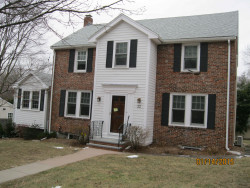
Property Use —
1 or 2 family dwelling

Properties Nearby

Street AddressResidens/Landlords
4 Avondale Rd, Newton, MA 02459-1619
Single Family
  • 3 beds
  • 1.5 baths
  • 2,730 sqft
  • Built in 1921
Cynthia A Hahn, Etta Suchman
 

FAQ about the house at 33 Avondale Rd, Newton, MA


NOTICE: You may not use RadioAwards or the information it provides to make decisions about employment, credit, housing or any other purpose that would require Fair Credit Reporting Act (FCRA) compliance. RadioAwards is not a Consumer Reporting Agency (CRA) as defined by the FCRA and does not provide consumer reports.