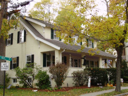
29 Brewster Rd, Newton MA  02461-1334 exterior

29 Brewster Rd Newton, MA 02461 / 1334

Residence for Single Family

(UPDATED: 08/07/2025)
  • 5 Beds
  • 2 Baths
  • 3.459 square feet
Property Report

Information about property on 29 Brewster Rd, Newton MA, 02461-1334. Find out owner contacts, building history, price, neighborhood at Homemetry Address Directory.

Property Details

As is shown in our records this property is placed at 29 Brewster Road, Newton, MA.

Facts

  • Built in 1930
  • Property use Single Family
  • Lot size 5,190 sqft
  • Effective area 3,459 sqft
  • Building type Residential
  • Rooms 8
  • Bedrooms 4
  • Bathrooms 1
  • Stories 2
  • Exterior condition Average
  • Trim None
  • Foundation type Concrete
  • Roof material Asphalt Shingl
  • Fuel type Oil
  • Air conditioning Central
  • Frontage 40 feet
  • Basement area 1,036 sqft
  • Shed area 96 sqft
  • Porch area 296 sqft
  • Heating & Cooling
  • Heat type Hot Wtr Radiat
  • Exterior Home Features
  • Exterior walls Stucco on Wood
  • Roof type Gable

Features

  • Kitchen quality: Above Average

Householders and Tenants for 29 Brewster Rd, Newton MA

Possible residents contact details

Person Name Phone Number Additional Info
Barbara C Guillette Age: 93
407-704-****
Residential status:
Homeowner
Frances M Obrien Age: 62
Residential status:
Homeowner
Francis Obrien Age: 63
Residential status:
Homeowner
Job:
Medical Professional
Gay Brown
617-244-****
Gayl Brown
617-244-****
Steph Guillette
617-630-****
Stephen Guillete
617-630-****
Stephen J Guillette Age: 62
617-630-****
Thelma Gaynell Brown Age: 91
617-771-****
Residential status:
Homeowner
Job:
Executive, Administrative, and Managerial Occupations
Walter A Brown
617-771-****
Residential status:
Homeowner
Job:
Executive, Administrative, and Managerial Occupations
29 Brewster Rd, Newton MA  02461-1334 plot plan 29 Brewster Rd, Newton MA  02461-1334 floor plan 29 Brewster Rd, Newton MA  02461-1334 aerial view

Purchase History

DateEventPriceSourceAgents
07/17/2003 Sold $601,800 Public records

Cost estimate history

YearAssessment
2016 $704,300
2015 $649,800
2014 $607,100
2013 $607,100
2012 $607,100
2011 $595,100
2010 $614,600
2009 $627,100
2008 $627,100
2007 $666,700
2006$647,300
2005$616,500
2004$566,400
2003$505,700
2002$505,700
2001$435,600
2000$397,800
1999$362,000
1998$343,800
1997$315,400
1996$300,400
1995$243,700
1994$229,900
1993$229,900
1992$236,500

Where is 29 Brewster Rd, Newton MA located on map?

Brewster Rd Fire Incident History

To date, we have no information about fire incidents in 2025
10 Jul 2010 Grass fire
Property Use —
Open land or field
Area of Origin —
Open area - outside; included are farmland, field
First Ignition —
Item First Ignited, Other
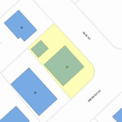
Properties Nearby

Street AddressResidens/Landlords
 

FAQ about the house at 29 Brewster Rd, Newton, MA


NOTICE: You may not use RadioAwards or the information it provides to make decisions about employment, credit, housing or any other purpose that would require Fair Credit Reporting Act (FCRA) compliance. RadioAwards is not a Consumer Reporting Agency (CRA) as defined by the FCRA and does not provide consumer reports.