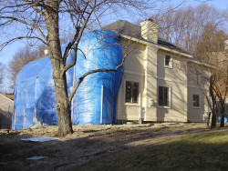

Purchase History
| Date | Event | Price | Source | Agents |
|---|---|---|---|---|
| 09/14/2010 | Sold | $1,790,000 | Public records | |
| 07/20/2009 | Sold | $610,000 | Public records |
Cost estimate history
| Year | Assessment | ||
|---|---|---|---|
| 2016 | $1,912,900 | ||
| 2015 | $1,787,800 | ||
| 2014 | $1,703,200 | ||
| 2013 | $1,703,200 | ||
| 2012 | $1,703,200 | ||
| 2011 | $1,475,900 | ||
| 2010 | $591,900 | ||
| 2009 | $604,000 | ||
| 2008 | $604,000 | ||
| 2007 | $608,900 | ||
| 2006 | $591,200 | ||
| 2005 | $563,000 | ||
| 2004 | $510,500 | ||
| 2003 | $455,800 | ||
| 2002 | $455,800 | ||
| 2001 | $369,600 | ||
| 2000 | $352,000 | ||
| 1999 | $320,300 | ||
| 1998 | $273,700 | ||
| 1997 | $264,400 | ||
| 1996 | $251,800 | ||
| 1995 | $235,800 | ||
| 1994 | $224,600 | ||
| 1993 | $224,600 | ||
| 1992 | $240,600 |
Hartman Rd Incidents registered in FEMA
(Federal Emergency Management Agency)
To date, we have no information about incidents registered in FEMA in 2025
23 Oct 2014
Electrical wiring/equipment problem, other
Property Use —
1 or 2 family dwelling
03 Jul 2010
Gasoline or other flammable liquid spill
Property Use —
Residential street, road or residential driveway
01 Oct 2008
Arcing, shorted electrical equipment
Property Use —
Street, other
21 Feb 2003
Medical assist, assist EMS crew
Property Use —
1 or 2 family dwelling
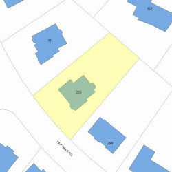
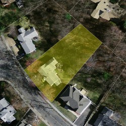
Properties Nearby
| Street Address | Residens/Landlords | |
|---|---|---|
30 Hartman Rd, Newton, MA 02459-3060 Single Family
|
Michael N Singh, Terra M Lafranchi |