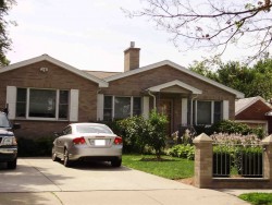
Cost estimate history
| Year | Assessment | ||
|---|---|---|---|
| 2016 | $579,400 | ||
| 2015 | $541,500 | ||
| 2014 | $505,300 | ||
| 2013 | $505,300 | ||
| 2012 | $505,300 | ||
| 2011 | $498,400 | ||
| 2010 | $508,600 | ||
| 2009 | $519,000 | ||
| 2008 | $519,000 | ||
| 2007 | $579,700 | ||
| 2006 | $562,800 | ||
| 2005 | $536,000 | ||
| 2004 | $313,200 | ||
| 2003 | $279,600 | ||
| 2002 | $279,600 | ||
| 2001 | $219,000 | ||
| 2000 | $200,000 | ||
| 1999 | $182,000 | ||
| 1998 | $162,500 | ||
| 1997 | $162,500 | ||
| 1996 | $154,800 | ||
| 1995 | $161,400 | ||
| 1994 | $168,100 | ||
| 1993 | $168,100 | ||
| 1992 | $187,200 |
Pearl St Fire Incident History
To date, we have no information about fire incidents in 2025
11 Mar 2007
Building fires
Property Use —
1 or 2 family dwelling
Area of Origin —
Common room, den, family room, living room, lounge
10 Aug 2002
Brush, or brush and grass mixture fire
Property Use —
Elementary school, including kindergarten
Area of Origin —
Open area - outside; included are farmland, field
First Ignition —
Light vegetation - not crop, including grass
29 May 2002
Outside rubbish fire, other
Property Use —
Outside or special property, other
Area of Origin —
Outside area, other
First Ignition —
Magazine, newspaper, writing paper
Heat Source —
Match
Pearl St Incidents registered in FEMA
(Federal Emergency Management Agency)
To date, we have no information about incidents registered in FEMA in 2025
09 Jul 2014
Gas leak (natural gas or LPG)
Property Use —
Residential street, road or residential driveway
12 Jun 2013
Gas leak (natural gas or LPG)
Property Use —
Residential street, road or residential driveway
18 Nov 2009
Vehicle accident, general cleanup
11 Mar 2007
Fire, other
Property Use —
1 or 2 family dwelling
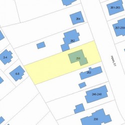
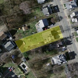
Properties Nearby
| Street Address | Residens/Landlords |
|---|