Information about property on 22 Brewster Rd, Newton MA, 02461-1302. Find out owner contacts, building history, price, neighborhood at
Homemetry Address Directory.
Property Details
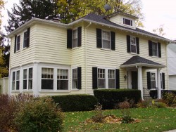
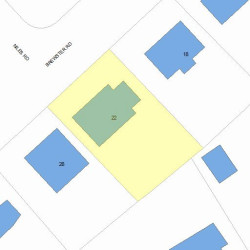
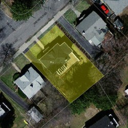
This is a single-family residence, which is situated at 22 Brewster Road, Newton, MA.
Facts
Built in1925
Property useSingle Family
Lot size5,900 sqft
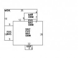
Effective area3,894 sqft
Gross building area4,310 sqft
Building typeResidential
Rooms8
Bedrooms3
Stories2
Exterior conditionAverage
TrimNone
Foundation typeConcrete
Roof materialAsphalt Shingl
Fuel typeOil
Frontage60 feet
Unfinished attic area416 sqft
Basement area958 sqft
Porch area40 sqft
Deck area374 sqft
Detached garage area240 sqft
Heating & Cooling
Heat typeSteam
Exterior Home Features
Exterior wallsClapboard
Roof typeHip
Features
Bath quality: Above Average
Interior condition: Good
Householders and Tenants for 22 Brewster Rd, Newton MA
What year was the house at 22 Brewster Rd, Newton, MA built?
The house at 22 Brewster Rd, Newton, MA was built in 1925.
What type of house is at 22 Brewster Rd, Newton, MA?
At the house at 22 Brewster Rd, Newton, MA type Residence for Single Family.
Have there been any fire incidents near the house at 22 Brewster Rd, Newton, MA?
The last fire incident at the house at 22 Brewster Rd, Newton, MA was in 2010. Other fire incidents of this house are available at the link.
NOTICE: You may not use RadioAwards or the information it provides to make decisions about employment, credit, housing or any other purpose that would require Fair Credit Reporting Act (FCRA) compliance. RadioAwards is not a Consumer Reporting Agency (CRA) as defined by the FCRA and does not provide consumer reports.