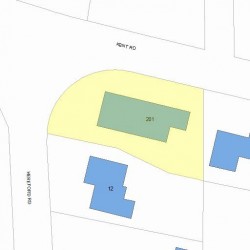
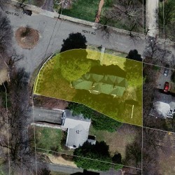
Information about property on 201 Kent Rd, Newton MA, 02468-1109. Find out owner contacts, building history, price, neighborhood at
Homemetry Address Directory.
Property Details
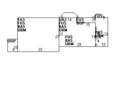
Built in 1910, this property has 6,069 sqft of effective area and sits on 0,28 acres.
Facts
Built in1910
Property useSingle Family
Lot size12,087 sqft
Effective area6,069 sqft
Gross building area6,817 sqft
Building typeResidential
Rooms9
Bedrooms5
Bathrooms3
Stories2,5
Exterior conditionAverage
TrimNone
Foundation typeBrick/Fldstone
Roof materialAsphalt Shingl
Fuel typeOil
Air conditioningUnit/AC
Fireplaces4
Frontage182 feet
Finished attic area446 sqft
Unfinished attic area304 sqft
Basement area1,564 sqft
Porch area352 sqft
Detached garage area380 sqft
Heating & Cooling
Heat typeSteam
Exterior Home Features
Exterior wallsStone
Roof typeGable
Features
Interior condition: Good
Householders and Tenants for 201 Kent Rd, Newton MA
What year was the house at 201 Kent Rd, Newton, MA built?
The house at 201 Kent Rd, Newton, MA was built in 1910.
What type of house is at 201 Kent Rd, Newton, MA?
At the house at 201 Kent Rd, Newton, MA type Residence for Single Family.
Were there any reported FEMA incidents at 201 Kent Rd, Newton, MA?
The last FEMA incident recorded at 201 Kent Rd, Newton, MA was in 2003. Other FEMA incidents registered on Kent Rd are available at the link.
NOTICE: You may not use RadioAwards or the information it provides to make decisions about employment, credit, housing or any other purpose that would require Fair Credit Reporting Act (FCRA) compliance. RadioAwards is not a Consumer Reporting Agency (CRA) as defined by the FCRA and does not provide consumer reports.