Information about property on 14 Prentice Rd, Newton MA, 02459-1343. Find out owner contacts, building history, price, neighborhood at
Homemetry Address Directory.
Property Details
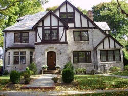
Originally built in the thirties, this property has approximately forty-seven hundred square feet of effective area.
Facts
Built in1930
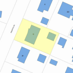
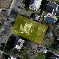
Lot size9,375 sqft
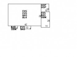
Effective area4,724 sqft
Gross building area5,716 sqft
Building typeResidential
Rooms10
Bedrooms5
Bathrooms4
Stories2,5
Exterior conditionAverage
TrimNone
Foundation typeBrick/Fldstone
Roof materialSlate
Fuel typeGas
Air conditioningCentral
Fireplaces2
Frontage78 feet
Basement area1,420 sqft
Finished basement area882 sqft
Porch area200 sqft
Detached garage area400 sqft
Heating & Cooling
Heat typeHot Water
Exterior Home Features
Exterior wallsBrick Veneer
Roof typeGable
Features
Kitchen quality: Good
Householders and Tenants for 14 Prentice Rd, Newton MA
What year was the house at 14 Prentice Rd, Newton, MA built?
The house at 14 Prentice Rd, Newton, MA was built in 1930.
What type of house is at 14 Prentice Rd, Newton, MA?
At the house at 14 Prentice Rd, Newton, MA type Residence for Single Family.
Were there any reported FEMA incidents at 14 Prentice Rd, Newton, MA?
The last FEMA incident recorded at 14 Prentice Rd, Newton, MA was in 2010. Other FEMA incidents registered on Prentice Rd are available at the link.
NOTICE: You may not use RadioAwards or the information it provides to make decisions about employment, credit, housing or any other purpose that would require Fair Credit Reporting Act (FCRA) compliance. RadioAwards is not a Consumer Reporting Agency (CRA) as defined by the FCRA and does not provide consumer reports.