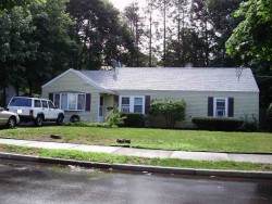
129 Spiers Rd, Newton MA  02459-3716 exterior

129 Spiers Rd Newton, MA 02459 / 3716

Residence for Single Family

(UPDATED: 07/15/2025)
  • 4 Beds
  • 1 Baths
  • 1.450 square feet
Property Report

Information about property on 129 Spiers Rd, Newton MA, 02459-3716. Find out owner contacts, building history, price, neighborhood at Homemetry Address Directory.

Property Details

This is a single-family estate, which is situated at 129 Spiers Road, Newton, MA.

Facts

  • Built in 1946
  • Property use Single Family
  • Lot size 7,032 sqft
  • Effective area 1,419 sqft
  • Gross building area 1,450 sqft
  • Building type Residential
  • Rooms 6
  • Bedrooms 4
  • Exterior condition Average
  • Trim None
  • Foundation type Slab
  • Roof material Asphalt Shingl
  • Fuel type Gas
  • Air conditioning Unit/AC
  • Frontage 68 feet
  • Heating & Cooling
  • Heat type Hot Wtr Radiat
  • Exterior Home Features
  • Exterior walls Vinyl Siding
  • Roof type Gable

Householders and Tenants for 129 Spiers Rd, Newton MA

Possible residents contact details

Person Name Phone Number Additional Info
Douglas A Sprenger
Eunita Morgan
Gary R Bearfield
JACOB NIGEL ST CLAIR
Jacob Nigel
Residential status:
Renter
Job:
Service Occupations
Jacob T Liptay
617-916-****
John S C Wong
Karen N Sprenger
Lissette Rosario Age: 59
Lizette Flores
617-244-****
M & M WONG TRUST /S TRS
N Liptay
617-916-****
N Liptay-Jacob
617-916-****
Nigel S Jacob Age: 52
617-916-****
Patricia Aubert
Patricia Bearfield
RIGGINS HOLDINGS LLC
Sally B Lim
T L Jacob
617-916-****
T Liptay
617-916-****
T Liptay-Jacob
617-916-****
Theodore B Swartz
Tiffany E Liptay Age: 51
617-916-****
Tiffany Jacob
Victor G Rosario Age: 37
Residential status:
Homeowner
Yolanda M Murray Age: 47
617-527-****
129 Spiers Rd, Newton MA  02459-3716 plot plan 129 Spiers Rd, Newton MA  02459-3716 floor plan 129 Spiers Rd, Newton MA  02459-3716 aerial view

Purchase History

DateEventPriceSourceAgents
04/20/2000 Sold $240,000 Public records

Cost estimate history

YearAssessment
2016 $342,500
2015 $320,100
2014 $304,200
2013 $304,200
2012 $304,200
2011 $303,800
2010 $310,000
2009 $316,300
2008 $316,300
2007 $361,500
2006$351,000
2005$334,300
2004$274,200
2003$244,800
2002$244,800
2001$214,100
2000$195,500
1999$177,900
1998$167,200
1997$153,400
1996$153,400
1995$147,100
1994$144,200
1993$144,200
1992$155,100

Where is 129 Spiers Rd, Newton MA located on map?

Spiers Rd Incidents registered in FEMA
(Federal Emergency Management Agency)

To date, we have no information about incidents registered in FEMA in 2025
22 Apr 2006 Arcing, shorted electrical equipment
Property Use —
1 or 2 family dwelling
28 Oct 2005 Chimney or flue fire, confined to chimney or flue
Property Use —
1 or 2 family dwelling
04 Oct 2005 Gas leak (natural gas or LPG)
Property Use —
1 or 2 family dwelling
13 Aug 2005 Electrical wiring/equipment problem, other
Property Use —
1 or 2 family dwelling

View more

Properties Nearby

Street Address Residens/Landlords
 

FAQ about the house at 129 Spiers Rd, Newton, MA


NOTICE: You may not use RadioAwards or the information it provides to make decisions about employment, credit, housing or any other purpose that would require Fair Credit Reporting Act (FCRA) compliance. RadioAwards is not a Consumer Reporting Agency (CRA) as defined by the FCRA and does not provide consumer reports.