12 Carter St, Newton MA  02460-2006 exterior

12 Carter St Newton, MA 02460 / 2006

Residence for Single Family

(UPDATED: 07/11/2025)
  • 3 Beds
  • 1 Baths
  • 2.401 square feet
Property Report

Information about property on 12 Carter St, Newton MA, 02460-2006. Find out owner contacts, building history, price, neighborhood at Homemetry Address Directory.

Property Details

Put up in 1910, this property has near nineteen hundred square feet of effective area and sits on 0,08 acres.

Facts

  • Built in 1910
  • Property use Single Family
  • Lot size 3,375 sqft
  • Effective area 1,852 sqft
  • Gross building area 2,401 sqft
  • Building type Residential
  • Rooms 7
  • Bedrooms 3
  • Bathrooms 1
  • Stories 2
  • Exterior condition Average
  • Trim None
  • Foundation type Concrete
  • Roof material Asphalt Shingl
  • Fuel type Oil
  • Frontage 45 feet
  • Basement area 732 sqft
  • Finished basement area 183 sqft
  • Porch area 15 sqft
  • Enclosed porch area 190 sqft
  • Detached garage area 399 sqft
  • Heating & Cooling
  • Heat type Hot Water
  • Exterior Home Features
  • Exterior walls Vinyl Siding
  • Roof type Gable

Features

  • Kitchen quality: Below Average

Householders and Tenants for 12 Carter St, Newton MA

Possible residents contact details

Person Name Phone Number Additional Info
Catherine T Allosso Age: 110
617-244-****
Cheryl A Lindner Age: 59
617-244-****
Derek Lindner Age: 38
617-244-****
FERREIRA-IANNONE SANDRA C
James T Allosso Age: 110
617-244-****
Jonathan T Iannone
Nancy M Lindner
617-244-****
Richard J Allosso
Richard Lindner Age: 61
Residential status:
Renter
Job:
Machine Operators, Assemblers, and Inspectors Occupations
Sandra Ferreira Age: 60
617-916-****
12 Carter St, Newton MA  02460-2006 plot plan 12 Carter St, Newton MA  02460-2006 floor plan 12 Carter St, Newton MA  02460-2006 aerial view

Cost estimate history

YearAssessment
2016 $484,700
2015 $453,000
2014 $433,200
2013 $433,200
2012 $433,200
2011 $431,500
2010 $440,300
2009 $449,300
2008 $449,300
2007 $465,600
2006$452,000
2005$430,500
2004$394,000
2003$351,800
2002$351,800
2001$286,500
2000$261,600
1999$238,000
1998$218,300
1997$203,100
1996$193,400
1995$176,800
1994$176,800
1993$176,800
1992$177,000

Where is 12 Carter St, Newton MA located on map?

Carter St Incidents registered in FEMA
(Federal Emergency Management Agency)

To date, we have no information about incidents registered in FEMA in 2025
18 Aug 2003 Medical assist, assist EMS crew
Property Use —
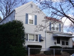
1 or 2 family dwelling
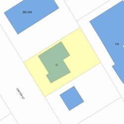
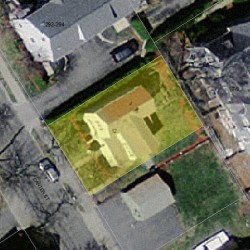
Properties Nearby

Street AddressResidens/Landlords
9 Carter St, Newton, MA 02460-2006
Single Family
  • 2 beds
  • 1 bath
  • 2,114 sqft
  • Built in 1900
James Arsenault, Kevin Arsenault
11 Carter St, Newton, MA 02460-2006
Multiple Occupancy
  • 6 beds
  • 3 baths
  • Lot: 3,000 sqft
  • Built in 1900
Jason W Kahn, Jason Khan
Sean J Tr Leary, 15 CARTER STREET REALTY TRUST /S TR
18 Carter St, Newton, MA 02460-2006
Housing Authority
  • 4 beds
  • 1,998 sqft
  • Built in 1982
Willie C Baker, Laura A Garinger
19 Carter St, Newton, MA 02460-2006
Condominium (Residential)
  • 4 beds
  • 2 baths
  • Lot: 8,463 sqft
  • Built in 1999
Ruiping He, Zhifeng Ren
20 Carter St, Newton, MA 02460-2006
Housing Authority
  • 4 beds
  • 1,998 sqft
  • Built in 1982
Anita Macomber, Anita N Mbaziira
21 Carter St, Newton, MA 02460-2006
Condominium (Residential)
  • 4 beds
  • 2 baths
  • Lot: 8,463 sqft
  • Built in 1999
Caroline M Apovian, August J Baker
22 Carter St, Newton, MA 02460-2006
Single Family
  • 2 beds
  • 1 bath
  • 1,868 sqft
  • Built in 1896
Jean C Curran, Paul Charbonnier
Ivan Drago
 

FAQ about the house at 12 Carter St, Newton, MA


NOTICE: You may not use RadioAwards or the information it provides to make decisions about employment, credit, housing or any other purpose that would require Fair Credit Reporting Act (FCRA) compliance. RadioAwards is not a Consumer Reporting Agency (CRA) as defined by the FCRA and does not provide consumer reports.