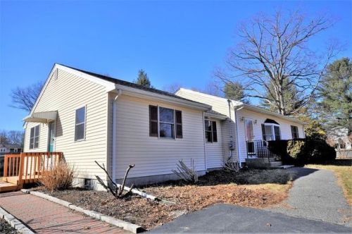
119 Hill Top Rd Whitman, MA 02382 / 1706

Residence for Single Family

(UPDATED: 07/30/2025)
  • 3 Beds
  • 1 Baths
  • 1.701 square feet
Sold Mar 2018
$344,900
Property Report

Information about property on 119 Hill Top Rd, Whitman MA, 02382-1706. Find out owner contacts, building history, price, neighborhood at Homemetry Address Directory.

Property Details

This is a capacious single-family one-story residence, which is situated at 119 Hill Top Road, Whitman, MA.

Facts

  • Built in 1959
  • Lot size 0,35 acres
  • Floor size 1,701 sqft
  • Rooms 6
  • Bedrooms 3
  • Bathrooms 1,5
  • Stories 1
  • Heating & Cooling
  • Heat type Forced air
  • Exterior Home Features
  • Exterior material Vinyl
  • Roof type Asphalt

Listing info

  • Last sold Jan 2010 for $1

Householders and Tenants for 119 Hill Top Rd, Whitman MA

Possible residents contact details

Person Name Phone Number Additional Info
Cindy Derrane
781-857-****
Cynthia J Derrane Age: 55
781-857-****
Residential status:
Homeowner
Job:
Handlers, Equipment Cleaners, Helpers, and Laborers Occupations
Edward A Kerr Age: 93
339-469-****
Residential status:
Homeowner
Job:
Homemaker
Frances I Kerr Age: 89
339-469-****
Residential status:
Homeowner
Job:
Retired
James Alfred
James P Derrane Age: 60
781-857-****
Leonard A Kerr Age: 98
339-469-****
Michael C Derrane Age: 55
781-857-****
Residential status:
Homeowner
Job:
Handlers, Equipment Cleaners, Helpers, and Laborers Occupations
Michael G Mazzarella Age: 36
Paul C Derrane
781-857-****
Robert A Kerr Age: 94
339-469-****
Virginia M Derrane Age: 87
781-857-****

Where is 119 Hill Top Rd, Whitman MA located on map?

Market Activities

To date, we have no information about market activities in 2025
Mar 2018 Sold
119 Hill Top Rd
Price history :
  • 1,701
  • 3 beds
  • 2 baths

View more

119 Hill Top Rd incidents registered in FEMA
(Federal Emergency Management Agency)

To date, we have no information about incidents registered in FEMA in 2025
06 Jan 2002 EMS call, excluding vehicle accident with injury
Property Use —
1 or 2 family dwelling
18 Oct 2001 Lock-out
Property Use —
1 or 2 family dwelling

Hl Top Rd Incidents registered in FEMA
(Federal Emergency Management Agency)

To date, we have no information about incidents registered in FEMA in 2025
07 Feb 2007 Chimney or flue fire, confined to chimney or flue
Property Use —
1 or 2 family dwelling
29 Oct 2003 Electrical wiring/equipment problem, other
Property Use —
Residential street, road or residential driveway
13 Jul 2003 EMS call, excluding vehicle accident with injury
Property Use —
1 or 2 family dwelling
26 Mar 2003 EMS call, excluding vehicle accident with injury
Property Use —
1 or 2 family dwelling

View more

Properties Nearby

Street AddressResidens/Landlords
38 Hl Top Rd, Whitman, MA 02382-1707
Single Family
  • 2 beds
  • 1 bath
  • 1,779 sqft
  • Built in 1956
David L Andrade, Jon S Andrade
44 Hl Top Rd, Whitman, MA 02382-1707
Single Family
  • 3 beds
  • 1 bath
  • 1,773 sqft
  • Built in 1957
Jb Claims Consulting, Joan Bartlett
52 Hl Top Rd, Whitman, MA 02382-1707
Single Family
  • 3 beds
  • 1.5 baths
  • 1,291 sqft
  • Built in 1957
Walter B Barry, Danielle J Rhoades
 

FAQ about the house at 119 Hl Top Rd, Whitman, MA


NOTICE: You may not use RadioAwards or the information it provides to make decisions about employment, credit, housing or any other purpose that would require Fair Credit Reporting Act (FCRA) compliance. RadioAwards is not a Consumer Reporting Agency (CRA) as defined by the FCRA and does not provide consumer reports.