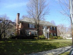
Cost estimate history
| Year | Assessment | ||
|---|---|---|---|
| 2016 | $1,924,800 | ||
| 2015 | $1,798,900 | ||
| 2014 | $1,716,900 | ||
| 2013 | $1,716,900 | ||
| 2012 | $1,716,900 | ||
| 2011 | $1,810,000 | ||
| 2010 | $1,802,700 | ||
| 2009 | $1,937,200 | ||
| 2008 | $1,937,200 | ||
| 2007 | $1,800,200 | ||
| 2006 | $1,747,800 | ||
| 2005 | $1,664,600 | ||
| 2004 | $1,468,300 | ||
| 2003 | $1,228,900 | ||
| 2002 | $1,228,900 | ||
| 2001 | $1,029,600 | ||
| 2000 | $940,300 | ||
| 1999 | $855,600 | ||
| 1998 | $847,100 | ||
| 1997 | $806,800 | ||
| 1996 | $768,400 | ||
| 1995 | $662,000 | ||
| 1994 | $630,500 | ||
| 1993 | $630,500 | ||
| 1992 | $650,700 |
Dartmouth St Incidents registered in FEMA
(Federal Emergency Management Agency)
To date, we have no information about incidents registered in FEMA in 2025
29 Oct 2012
Hazardous condition, other
Property Use —
Residential street, road or residential driveway
04 Sep 2010
Power line down
Property Use —
Residential street, road or residential driveway
29 Nov 2003
EMS call, excluding vehicle accident with injury
Property Use —
1 or 2 family dwelling
14 Aug 2003
Rescue, emergency medical call (EMS) call, other
Property Use —
Construction site
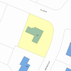
Properties Nearby
| Street Address | Residens/Landlords | |
|---|---|---|
10 Dartmouth St, Newton, MA 02465-2602 Single Family
|
DARTMOUTH STREET REALTY TRUST /S TR, Tracy M Tr Dowd |