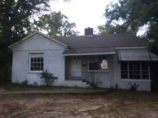
Cost estimate history
| Year | Tax | Assessment | Market |
|---|---|---|---|
| 2013 | N/A | $20,280 | $50,700 |
Market Activities
Marshall Ave Fire Incident History
To date, we have no information about fire incidents in 2025
12 May 2012
Building fires
Property Use —
1 or 2 family dwelling
Area of Origin —
Cooking area, kitchen
First Ignition —
Cooking materials, including edible materials
Heat Source —
Heat from powered equipment, other
12 Apr 2009
Brush, or brush and grass mixture fire
Property Use —
Vacant lot
Area of Origin —
Open area - outside; included are farmland, field
First Ignition —
Light vegetation - not crop, including grass
Heat Source —
Cigarette
28 Apr 2007
Grass fire
Property Use —
Residential street, road or residential driveway
Area of Origin —
Open area - outside; included are farmland, field
First Ignition —
Light vegetation - not crop, including grass
Heat Source —
Cigarette
10 Aug 2002
Outside equipment fire
Property Use —
1 or 2 family dwelling
Area of Origin —
Courtyard, patio, porch, terrace
First Ignition —
Flammable liquid/gas - in/from engine or burner
Heat Source —
Spark, ember or flame from operating equipment
404 Marshall incidents registered in FEMA
(Federal Emergency Management Agency)
To date, we have no information about incidents registered in FEMA in 2025
18 May 2015
Unauthorized burning
Property Use —
1 or 2 family dwelling
Marshall Ave Incidents registered in FEMA
(Federal Emergency Management Agency)
To date, we have no information about incidents registered in FEMA in 2025
18 May 2015
Unauthorized burning
Property Use —
1 or 2 family dwelling
21 Aug 2008
Power line down
Property Use —
Street, other
13 Mar 2008
Unauthorized burning
Property Use —
Graded and cared-for plots of land
28 Sep 2005
Cooking fire, confined to container
Property Use —
Multifamily dwellings
Properties Nearby
| Street Address | Residens/Landlords | |
|---|---|---|
400 Marshall Ave, Warner Robins, GA 31093-3328 Single Family Residential
|
Benjamin Braun, Keith Crawford |