


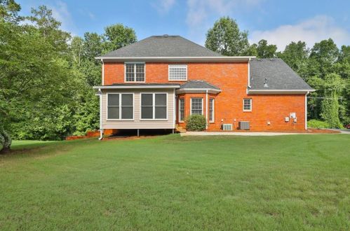
Cost estimate history
| Year | Tax | Assessment | Market |
|---|---|---|---|
| 2014 | $1,241 | N/A | N/A |
| 2013 | N/A | $71,280 | $112,600 |
Market Activities
2246 Mcdaniel Mill Rd Fire Incident History
To date, we have no information about fire incidents in 2025
19 May 2000
Cultivated grain or crop fire
Property Use —
1 or 2 family dwelling
Area of Origin —
Other
First Ignition —
Item First Ignited, Other
Mcdaniel Ml Rd Fire Incident History
To date, we have no information about fire incidents in 2025
10 Mar 2017
Brush, or brush and grass mixture fire
Property Use —
Open land or field
Area of Origin —
Wildland, woods
First Ignition —
Heavy vegetation - not crop, including trees
Heat Source —
Arcing
10 Mar 2016
Brush, or brush and grass mixture fire
Property Use —
Open land or field
Area of Origin —
Wildland, woods
First Ignition —
Light vegetation - not crop, including grass
Heat Source —
Flying brand, ember, spark
24 Oct 2000
Cultivated grain or crop fire
Property Use —
Residential, other
Area of Origin —
Open area - outside; included are farmland, field
First Ignition —
Multiple items first ignited
19 May 2000
Cultivated grain or crop fire
Property Use —
1 or 2 family dwelling
Area of Origin —
Other
First Ignition —
Item First Ignited, Other
Mcdaniel Ml Rd Incidents registered in FEMA
(Federal Emergency Management Agency)
To date, we have no information about incidents registered in FEMA in 2025
18 May 2003
Rescue, emergency medical call (EMS) call, other
Property Use —
1 or 2 family dwelling
07 Jun 2000
Outside rubbish fire, other
Property Use —
1 or 2 family dwelling
22 Apr 2000
Natural vegetation fire, other
Property Use —
1 or 2 family dwelling
Properties Nearby
| Street Address | Residens/Landlords |
|---|