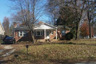
Cost estimate history
| Year | Tax | Assessment | Market |
|---|---|---|---|
| 2014 | $1,262 | $128,900 | $128,900 |
Market Activities
Gary Ave Fire Incident History
To date, we have no information about fire incidents in 2025
23 Dec 2012
Mobile property (vehicle) fire, other
Property Use —
Residential street, road or residential driveway
Area of Origin —
Cargo/trunk area - all vehicles
First Ignition —
Appliance housing or casing
Heat Source —
Radiated heat from another fire
23 Oct 2012
Cooking fire, confined to container
Property Use —
1 or 2 family dwelling
Area of Origin —
Cooking area, kitchen
First Ignition —
Cooking materials, including edible materials
Heat Source —
Heat from powered equipment, other
24 May 2006
Building fires
Property Use —
1 or 2 family dwelling
Area of Origin —
Cooking area, kitchen
First Ignition —
Household utensils
Heat Source —
Hot or smoldering object, other
29 Mar 2006
Forest, woods or wildland fire
Property Use —
Open land or field
Area of Origin —
Wildland, woods
First Ignition —
Light vegetation - not crop, including grass
Gary Ave Incidents registered in FEMA
(Federal Emergency Management Agency)
To date, we have no information about incidents registered in FEMA in 2025
23 Nov 2015
Unauthorized burning
Property Use —
1 or 2 family dwelling
07 Jun 2010
Electrical wiring/equipment problem, other
Property Use —
1 or 2 family dwelling
15 Sep 2009
Unauthorized burning
Property Use —
Open land or field
10 Mar 2007
Unauthorized burning
Property Use —
Graded and cared-for plots of land
Properties Nearby
| Street Address | Residens/Landlords |
|---|